FRENCHMANS CAP WALK©
TONY & MATTHEW WATTON
17/8/07 to 20/8/07
Day 1 - Friday 17/8/07
We started our walk in less than ideal conditions. Matthew still needed to pack when we arrived at the Lyell Highway car park because he had worked until 1.00am that morning. We set up his lightweight fly sheet between unobliging trees at the off-road car park in penetrating drizzle/light rain to pack and change into our walking gear.
There were no other cars at the car park, which was an indication that there were probably no walkers on the Frenchmans Cap Track (unless they had arrived by bus of course).
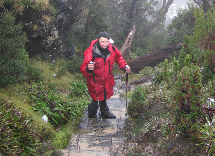
We were ready to go, with our 21kgs packs, at 2.20pm, a bit later than we had wanted. We knew the walk to Lake Vera Hut had taken us 6 hours in good conditions on our previous trip [Frenchmans Cap Walk - December 2003] when the Loddon Plains were unusually dry, so we expected to be walking using our head torches at least some of the way. I can't say I was really looking forward to that prospect!
The walk out to the suspension bridge over the Loddon River was uneventful. However, there was some evidence of recent flooding and storm damage on the way and Matthew cleared some tree branches and debris from the Loddon River bridge, which was an indication of the height of the river a week or so earlier.
By the time we had walked about 3kms over the Loddon Plains, with much bog and water covering the track, it was dark enough to switch on our head torches - about 6.00pm. This effectively reduced our pace even more because it was so difficult to judge distance with a narrow cone of light ahead. We were both glad we had decided to use our trekking poles to help in keeping our balance and to gauge the depth of the mud before committing to stepping in it. Even so, it was still very difficult to extract a leg when I went in at knee depth.
We plodded on, turning SW along Philps Lead and found the narrow, rocky track had become a running creek. We had trouble finding where the track left Philps Creek because a massive amount of forest debris had been brought down, to a depth of at least 1 metre in places. We dropped our packs in the least wet area we could find and Matthew got our position on his GPS. We were in the right spot but could not see the track. Matthew suggested that I wait where we were while he did a bit of exploring to try to find the track. For a while I could see his head torch light as he moved around up the hill but I began to get concerned that he might not be able to see my head light when he returned as I was situated in a bit of a hollow.
After about 20 minutes I began to get worried when I couldn't see his light so gave a series of cooees. However, I found out later he couldn't hear me because of roaring water in Philps Creek. I was in a dilemma as I wanted to find him but didn't want to lose the packs in the process.
I was very relieved when he reappeared. He told me he was never lost because he moved back to the main creek from time to time and eventually followed it down to my light. Whilst he was moving away from Philps Creek bed he stepped into very soft silt and quickly sank to his waist. If he had not been able to pull himself out by using the branches nearby it would have been very serious.
After that we decided that if we couldn't find the track forwards then, distasteful as it was, safety dictated that we should retrace our steps until we found a campsite for the night and re-assess our position in the morning.
As we started back down the devastated creek we had a look towards the right of the creek route to see if the track continued that way. Imagine our relief when Matthew announced that he had found the correct route.
[On returning home my wife, Suzanne, suggested maybe it would have been a good idea to take our two-way radios with us on this trip. I could only agree. However, we had an EPIRB for real emergencies - fortunately not needed - and there were a lot of other things it would have been nice to take as well!]
Moving away from the creek meant that, although the track became much drier, a steep climb along a narrow, rocky trench was not such a welcome result. The track then levelled out and we crossed a plain before descending steeply on a good track to reach Lake Vera Hut.
We were amazed that it was 11.00pm - the walk in having taken 8 hours 40 minutes in total. Of this, about 5 hours were done with head torches.
In retrospect a better option may have been to camp at nightfall and continue to Lake Vera Hut in daylight on Saturday.
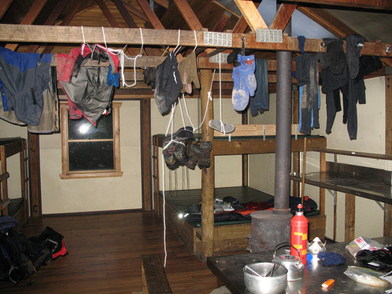
There were no other walkers at the hut. We immediately changed into our dry clothes. Matthew started up his MSR stove to make us a hot drink while I started work on the coal stove to get the hut temperature up from the 4oC showing on the thermometer. We were thankful that the previous lone walker, we believe a Mr Shapiro from New York City, had left the stove clean, coal buckets full and kindling wood in the storage box. Between us we got the stove going and festooned the stove surrounds with our wet clothes while we enjoyed our hot chocolate drink and snack in total comfort.
A quick look at the log book and we climbed into our sleeping bags by about 1.15am, happy to have reached the hut unscathed.
Day 2 - Saturday 18/8/07
Rest day. Light rain and very little visibility. No surrounding peaks in view.
We got up late, maybe 9 am, and talked about what we might do on Sunday.
Option 1 - walk back to the car park - not preferred.
Option 2 - stay at Lake Vera Hut another day - what then? - not preferred.
Option 3 - head up to Barron Pass and possibly on to Lake Tahune Hut to re-assess further action - preferred option.
Option 4 - go up to Frenchmans Cap after Option 3 - probably not practical if there was heavy snow and/or ice on the ascent track - not preferred.
Day 3 - Sunday 19/8/07
We were up reasonably early, about 6.15am, had warm mountain bread with Nutella spread and a cup of tea, packed our day packs with essentials and were on the track to Lake Tahune Hut by 8.45am.
The going was quite reasonable, considering the light packs, good track and the fact that we had had a break from walking the previous day.
Even so, the steep climb up to Barron Pass was slow but uneventful. It was a pity the spectacular views were hidden by the low cloud/fog/mist/drizzle that kept us company. We were amazed at the results of the recent storms in the area. There was a lot of debris on the track and some trees had been blown down.
We wondered at the age of some of the pandani plants we saw. Some had up to 5 branches growing from a single fallen trunk, which was about 5m or 6m in length. Matthew identified some fallen leaves as from the deciduous beech (Nothofagus family) and was interested to see what he thought was a variety of Banksia marginata with a smooth end to the leaves (rather than being irregular at the ends).
The walk to Lake Tahune Hut took us 3½ hours, with patches of old snow at the higher levels, around 1,000m. No ice, fortunately.
The hut was a welcome sight but the lack of visibility reinforced our decision not to climb Frenchmans Cap. This was mainly because we had climbed the Cap once before [Frenchmans Cap Walk - December 2003] with zero visibility and we couldn't see the point in repeating the exercise with no prospect of enjoying a view from the top.
As we expected, the temperature in the hut was very low - the thermometer showed it as 3oC - but as we were very wet it seemed much colder to us.
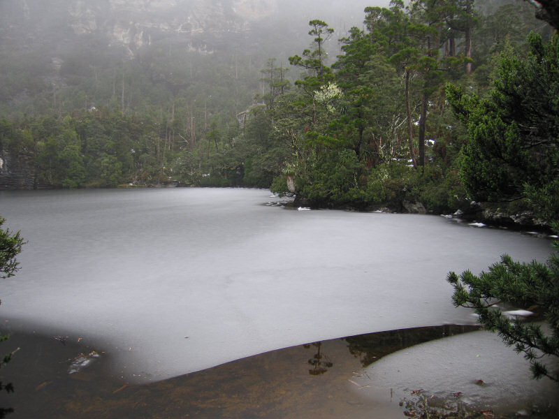
After studying the instructions we lit the 'on-trial' methylated spirits heater that Parks & Wildlife Service (P&WS) had provided. It is a very basic heater but any warmth was most welcome. We stayed only long enough to have a snack and a drink. Matthew took a photo of the frozen Lake Tahune and we then headed back with very cold hands and feet. Circulation soon returned with the exertion of climbing back up from the hut and visibility began to return as we walked through Artichoke Valley and approached Barron Pass again.
Approaching Lake Vera Matthew went on ahead as I plodded slowly on. I had a bit of a slip on a steep rock section where steps had been cut in the rock. One foot slipped and I slid down towards the lake. Fortunately, my slide was halted by a tree and I scrambled back up to the track. As I looked back I was relieved I had avoided a very cold dunking.
The return trip to Lake Vera Hut took just under 3 hours. We rewarded ourselves with a hot drink, Vitawheat biscuits with cheese slices and Vegemite and a cheerfully warm coal stove.
Day 4 - Monday 20/8/07
Up at 5.30am for what we knew would be a long trek back to the car park and, with a bit of luck, an intact, undamaged vehicle.
We made sure we had cleaned the hut, re-stocked the coal buckets and gathered some kindling for the next lucky occupants.
Hot drink, warm mountain bread with Nutella, and we were on the track by 7.20am.
There was a very light drizzle initially but that soon stopped and we enjoyed a pleasant day's walking.
When we reached the point where the track met Philps Creek we took some photos of the devastation and reviewed where we had been on the way in on Friday. Matthew tied a plastic bag (sorry, P&WS about the pollution) to a tree to indicate the correct route and we continued on our way down Philps Lead.
As we got into the Loddon Plains there was certainly a lot of bog but we both thought it could have been worse, considering there had been rain on each of the 4 days of our trip.
We were pacing ourselves to have a 10 minute break every hour to help stay alert as it was essential to maintain our concentration and strength.
The bog seemed to take for ever to negotiate as our progress was very slow but eventually we gained the higher ground of the Franklin Hills and Mount Mullens.
We reached the highway at 3.30pm, having not seen another person the entire trip and were very relieved to find the car just as we had left it 3 days previously. We changed into our clean clothes at the roadside and headed for Derwent Bridge where we enjoyed a hot snack at the service station before driving back to Hobart, very pleased with our trip along the Frenchmans Cap Track. We had come to within the last 400m of the Cap (vertically!) and still considered we had had a successful walk.
Thanks Matthew for being a great companion.