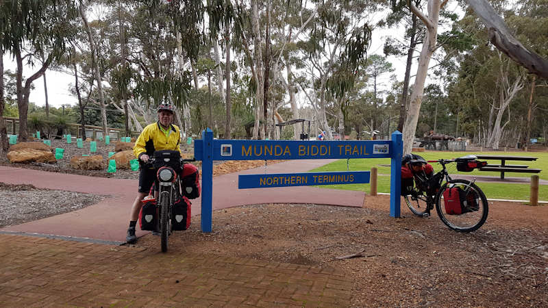
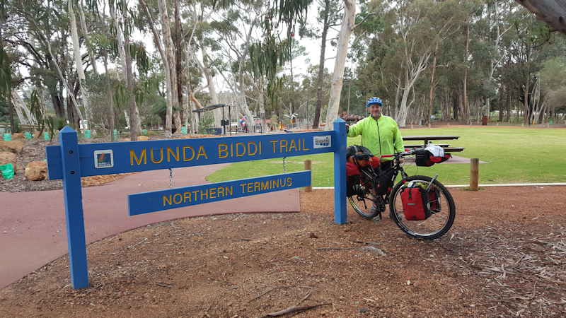
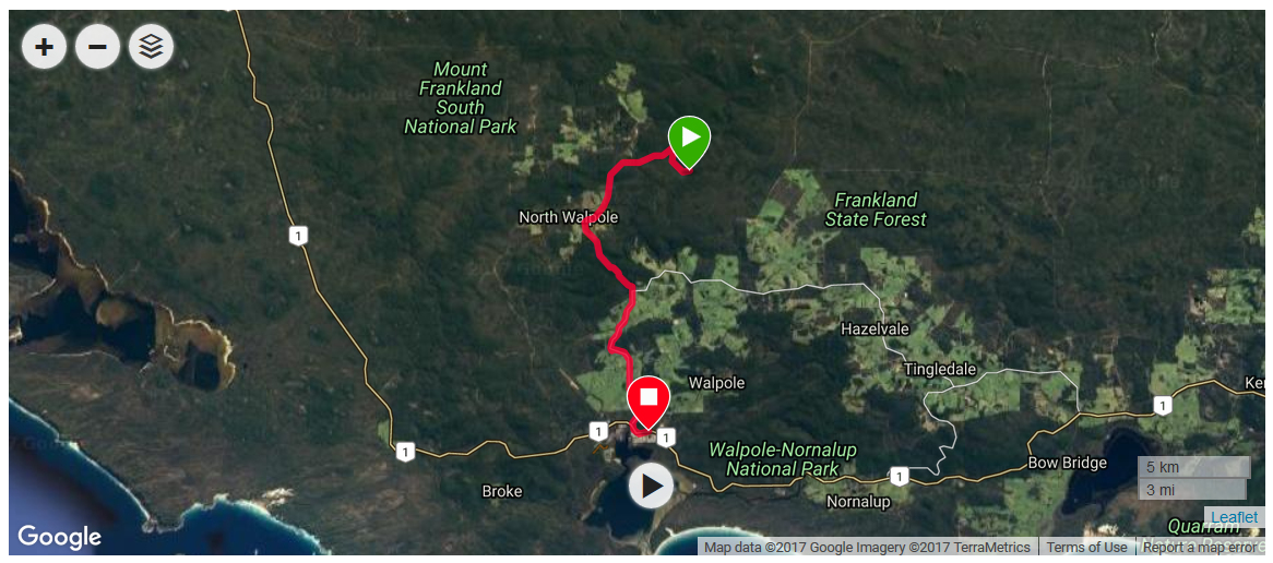
RIDING THE MUNDA BIDDI TRAIL
PERTH TO ALBANY
WESTERN AUSTRALIA
TONY AND MATTHEW WATTON
10/8/2017 to 6/9/2017
Before the Trail Ride Began
Our plan to ride the Munda Biddi Trail came about after Matthew read an account of a record-breaking ride of the 1,000kms trail in just over 4 days 6 hours by Perth's Declan von Dietze. Matthew had six weeks leave to fill in and thought it would be a good idea to spend the time away from Tasmania's winter and ride in the warmer South-West of Western Australia.
I wasn't sure if he was serious but when he told me he had bought a bike bag and booked his air travel I realised it was going to happen. I said it would be a fantastic trip. However, it was out of the question for me because the 16-year-old Maltese/Shih-tzu dog, Topsy, that Suzanne and I had was very sick and needed constant care. Eventually, on 26/6/17 we made the difficult decision to have her put to sleep. A day or two after this had occurred, Matthew made the suggestion that there was probably no reason why I could not also do this ride. I agreed and we immediately did a duplicate flight booking to match Matthew's.
During the following weeks Matthew kindly bought me a Chain Reactions bike bag, booked a storage locker at Storage King near Perth Airport and arranged a shuttle service from Albany back to Perth to coincide with the end of the ride. We also paid for excess baggage allowances in the hope that they would be sufficient to cover the cost of transporting our bikes to and from Perth.
Meanwhile, I was using my exercise bike daily during the Tour de France by doing 4 x 10 minute sets as well as some day rides of between 30 and 50kms. Was that enough?
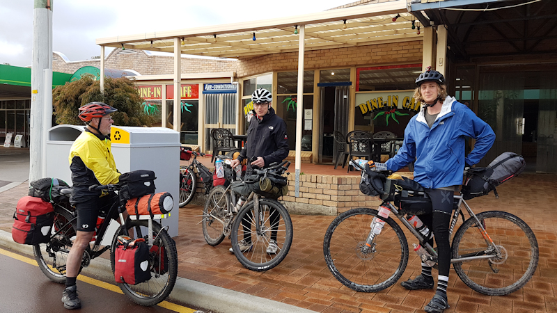
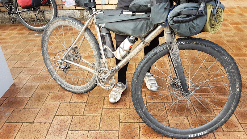
The bikes we took were both new prior to the adventure. Matthew had bought a Surly Ogre and I had a new Merida XT Edition Big 9. Both bikes were 29ers with 2.4" Continental Mountain King Protection tyres for me and 2.4" Maxxis Ardent for Matthew. I took the precaution of fitting tyre liners but Matthew thought his tyres were good enough as they were. We each carried one Mountain King tyre as a spare.
Our pannier racks were Tubus stainless steel with Ortlieb waterproof pannier bags and handlebar bags. I had a home-made front rack for my sleeping bag. My tent was on my rear rack. Matthew's tent was in a rear pannier and his sleeping bag was on his rear rack. He also had a frame bag for tools and other items that could be accessed quickly.
Tuesday 8/8/17 - Lauderdale to Perth Area
We left Hobart on a sunny morning on 8/8/17, having successfully booked in our bike bags with partially dismantled bikes and large back packs that brimmed full with all the equipment we would need for our bike ride. We expected to take about four weeks to complete the Trail, leaving a few days in Albany and Perth before heading back to Hobart on 16/9/17.
At Hobart Airport, despite having paid for one extra item of excess baggage we still each needed to pay an extra $50 for excess baggage. It was a huge relief to see our large packs and bike bags finally disappear into the bowels of the airport, leaving us with our cabin day packs.
The flights to Melbourne and on to Perth were uneventful but when we had collected our bikes and packs in Perth we then had to take them about 1km to the Storage King depot. This was a miserable struggle in the rain, with the bike bags constantly falling over to the side. We eventually made it to the storage depot, only to be kept waiting while an earlier customer took what we thought was an excessive amount of time negotiating their business. By the time we were dealt with it was about 4.30pm. We had expected to be able to set up our bikes and actually start towards the Trail (heading to accommodation on the way to Mundaring) during that afternoon but it soon became apparent that we would not be able to achieve that in daylight. At our turn we experienced a similar extended time spent on explaining the contract terms and conditions before we were eventually able to access the storage locker that Matthew had rented.
By this time it was raining heavily and the time was fast approaching 5.30pm. At this stage we planned to ride to the Banksia Tourist and Park Home (caravan park) - a distance of only about 9kms - before starting our real adventure on Wednesday 9/8.
Matthew called out to me that he was having trouble starting a bolt that held the lower end of his rear pannier rack to the bike frame. When I had a look it seemed as though the bolt had started with crossed threads. By putting the bolt in from the inside of the frame the threads became cleared, allowing the bolt to be inserted the correct way. Next, as we were busily reassembling our bikes next to the storage locker I heard a sudden loud metallic bang that came from where Matthew was working on his bike. Apparently, his rear wheel skewer had stripped the threads as he was tightening the QR clamp. He said he had previously had some trouble with the skewer and probably should have replaced it at that time. We did not have a spare skewer so we would need to buy a replacement the next day.
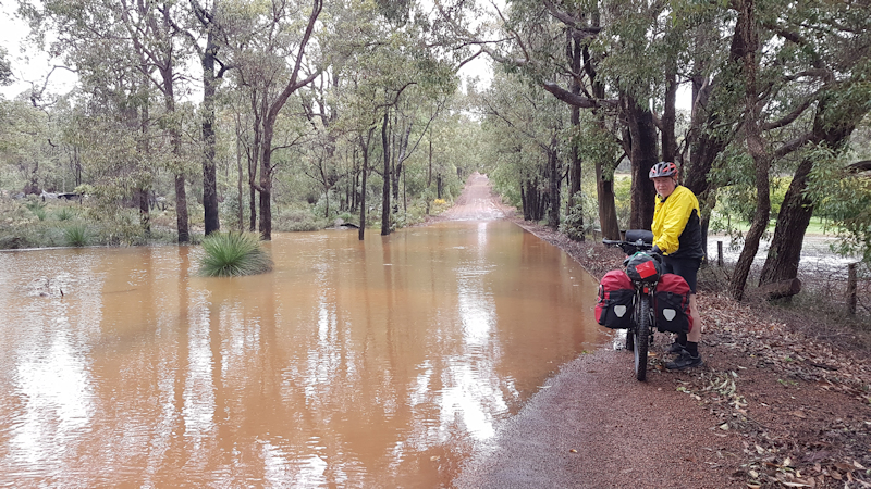
Because of this gear breakage we decided to leave the bulk of our gear in the small locker, get a cab to the caravan park and deal with the problem the next day. By the time we were on the road (by cab) the rain was torrential. We were glad we were heading to accommodation and not on the road in such conditions. [Later we learned that the rain had caused major flooding in some parts of Perth.]
After seeing the results of the deluge we decided to delay the start of our ride to begin on Thursday. This meant that we would have the opportunity to buy some food for the following day and to set up our bikes without having to rush to get moving before darkness approached. We spent a relaxing evening in the unit, in readiness for the real start of the trail ride.
Wednesday 9/8/17 - Perth Area
We wanted to ensure we were as prepared for the coming weeks as we could be so we booked ourselves into the Banksia Caravan Park for a second night. During the morning we got a cab to the nearest bike shop in Midland for the new skewer. While at the shop the assistant suggested we should buy extra brake pad sets because the gravel on the trail would wear brake pads out very quickly. Unfortunately, we did not know the exact pattern that we needed and would have to wait until we had our bikes to match new sets of brake pads with what we already had.
Our next stop was across the road at Midland Gate Shopping Centre to get our breakfast of a toasted sandwich and a drink before visiting a supermarket to get supplies for the following three days. From there we got another cab, this time to the storage warehouse back at the airport, where we packed our panniers in a rough fashion and started our first ride on fully laden bikes to find new brake pad sets. Perversely, we had to head back the wrong way towards Perth to the Bicycle Entrepreneur bike shop at Belmont. On this ride we experienced some of the bad weather that the Perth area was subjected to, but we did not have hail or flooded roads like other people did.
After the bike shop we rode along the Great Eastern Highway on the bike path for most of the way and were back at the Banksia Tourist Park by about 3.45pm, to unpack the panniers and make a more sensible job of re-packing them for the next day's ride.
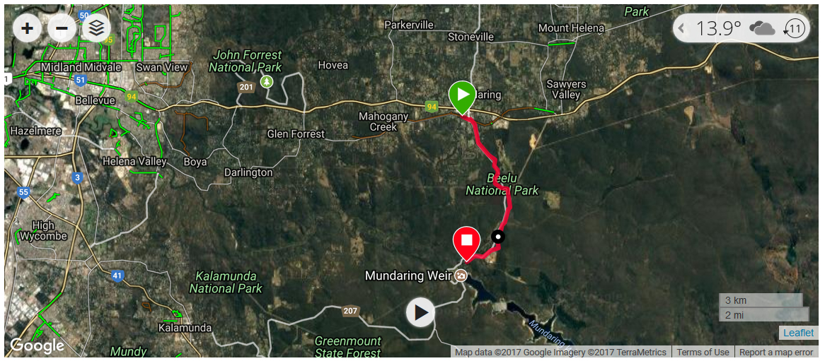
The plan for 10/8 was to ride to Mundaring - about 20kms - then on to Mundaring Weir - another 9kms - where we had booked ourselves into the hotel there.
We spent another comfortable evening in the unit. Dinner was two rolls with peanut butter and raspberry jam, followed by a cup of tea. Later we enjoyed cheese and biscuits and more tea. Outside, there was more rain, although not as much as during the day. We hoped for a better day on Thursday.
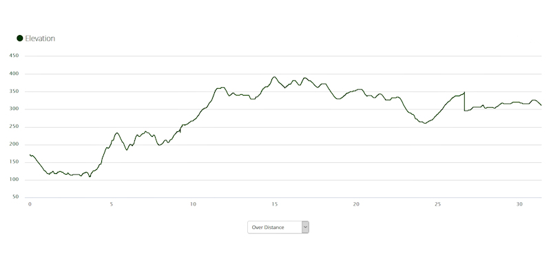
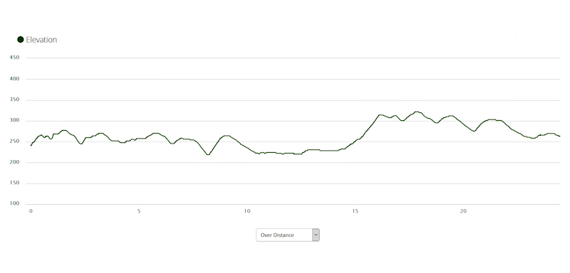
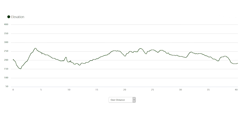
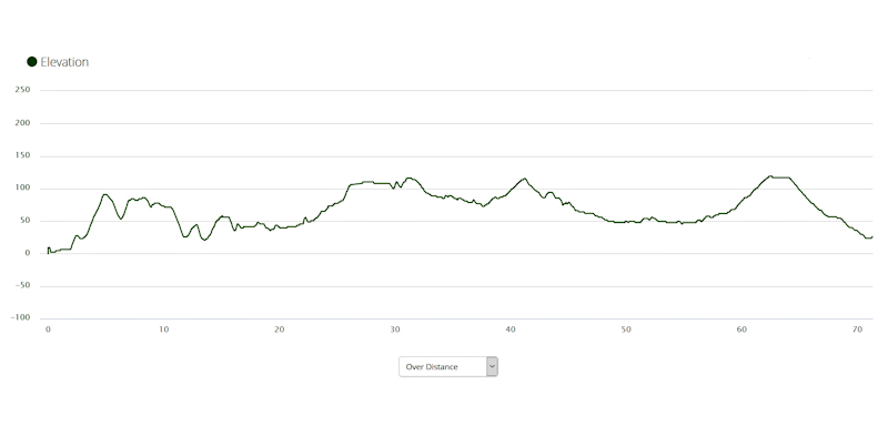
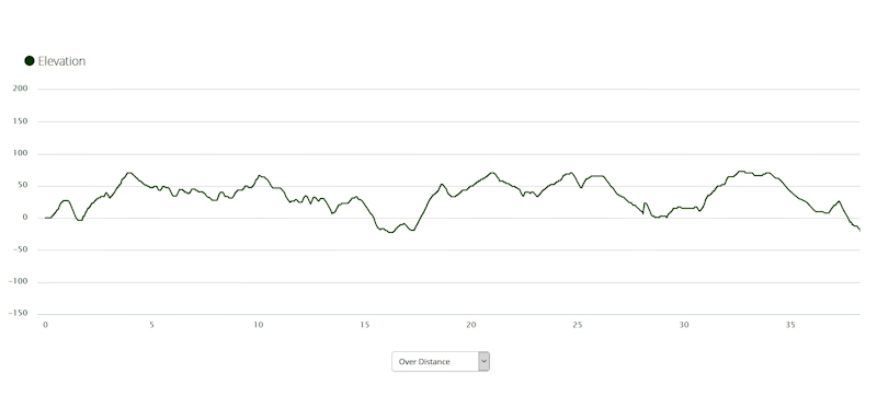
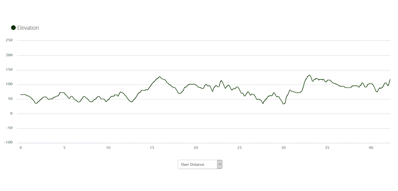
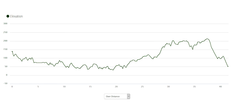
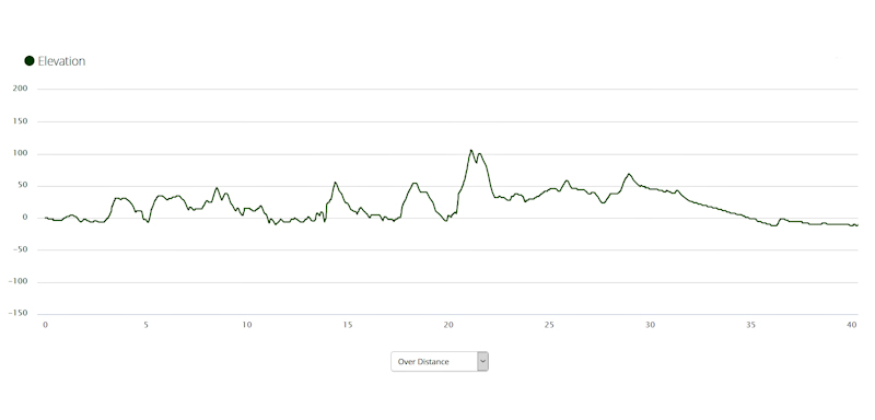
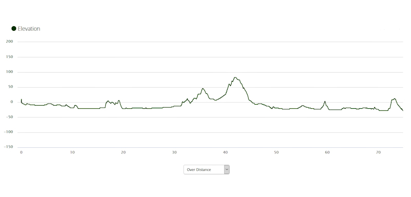
Stats for the Ride Days
| Day | Date | From | To | Distance (kms) | Total Time | Moving Time | Av Moving Speed (kms/hr) | Max Speed (kms/hr) |
| 1 | 10/8/17 | Hazelmere | Mundaring Weir | 28.7 | 4h 31m | 2h 33m | 11.5 | 48.9 |
| 2 | 11/8/17 | Mundaring Weir | Carinyah Hut | 31.4 | 6h 12m | 3h 51m | 8.2 | 36.0 |
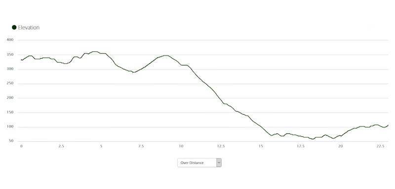
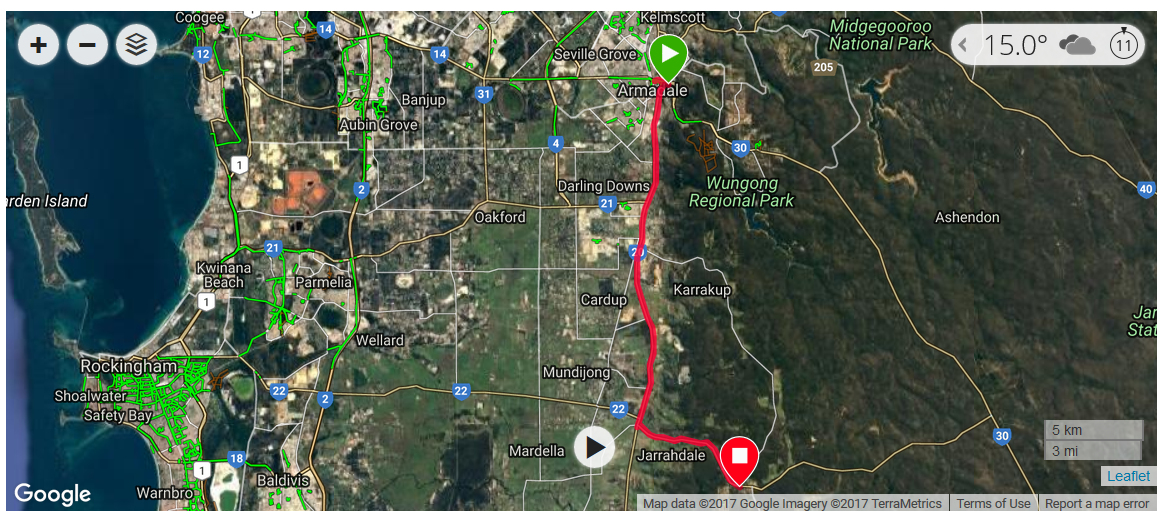
| 3 | 12/8/17 | Carinyah Hut | Armadale | 23.0 | 2h 18m | 1h 36m | 14.3 | 54.9 |
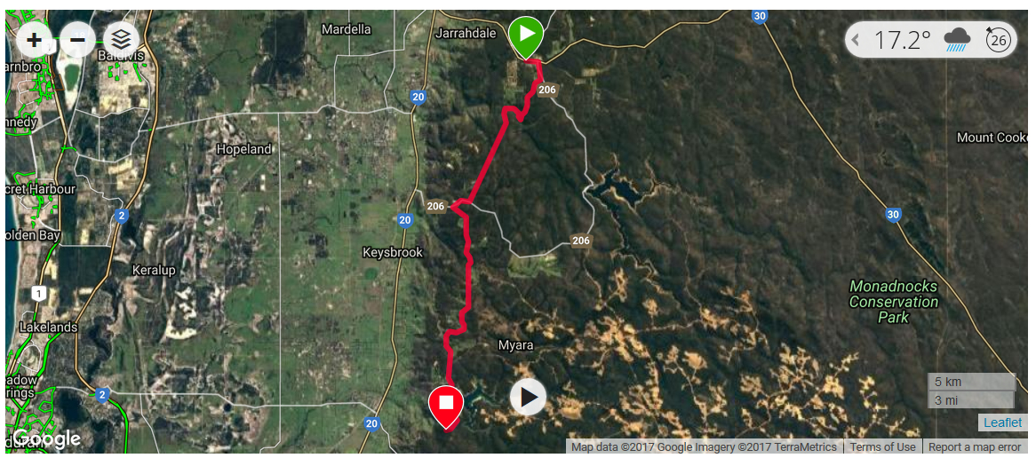
| 4 | 13/8/17 | Armadale | Jarrahdale | 27.3 | 2h 42m | 1h 55m | 14.1 | 45.1 |
| 5 | 14/8/17 | Jarrahdale | North Dandalup Hut | 23.6 | 3h 36m | 2h 17m | 10.3 | 43.3 |
| 6 | 15/8/17 | North Dandalup Hut | Dwellingup | 24.5 | 2h 39m | 1h 56m | 12.7 | 50.6 |
| 7 | 16/8/17 | Dwellingup | Bidjar Ngoulin Hut | 28.4 | 3h 46m | 2h 48m | 10.1 | 41.4 |
| 8 | 17/8/17 | Bidjar Ngoulin Hut | Lake Brockman | 35.3 | 4h 15m | 3h 15m | 10.8 | 46.6 |
| 9 | 18/8/17 | Rest Day at Lake Brockman | - | - | - | - | - | |
| 10 | 19/8/17 | Lake Brockman | Yarri Hut | 33.0 | 3h 34m | 2h 47m | 11.8 | 49.6 |
| 11 | 20/8/17 | Yarri Hut | Collie | 40.3 | 3h 59m | 3h 12m | 12.6 | 39.9 |
| 12 | 21/8/17 | Rest Day at Collie | - | - | - | - | - | |
| 13 | 22/8/17 | Collie | Nglang Boodja Hut | 36.1 | 6h 52m | 3h 13m | 11.0 | 41.8 |
| 14 | 23/8/17 | Nglang Boodja Hut | Donnybrook | 41.2 | 5h 9m | 3h 13m | 12.8 | 53.7 |
| 15 | 24/8/17 | Donnybrook | Nannup | 71.4 | 9h 42m | 5h 5m | 14.0 | 52.4 |
| 16 | 25/8/17 | Nannup | Donnelly Mill | 36.6 | 4h 42m | 3h 27m | 10.6 | 54.5 |
| 17 | 26/8/17 | Donnelly Mill | Manjimup | 48.6 | 7h 58m | 4h 46m | 10.2 | 44.7 |
| 18 | 27/8/17 | Manjimup | Quinninup | 36.2 | 3h 34m | 2h 42m | 13.4 | 56.6 |
| 19 | 28/8/17 | Quinninup | Pemberton | 38.3 | 4h 23m | 3h 20m | 11.5 | 51.1 |
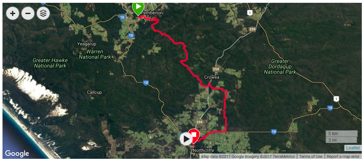
| 20 | 29/8/17 | Pemberton | Northcliffe | 45.3 | 6h 24m | 4h 18m | 10.5 | 44.4 |
| 21 | 30/8/17 | Northcliffe | Yirra Kartta Hut | 42.2 | 4h 33m | 3h 20m | 12.7 | 54.6 |
| 22 | 31/8/17 | Yirra Kartta Hut | Kwokralup Beela Hut | 41.5 | 5h 36m | 3h 49m | 10.9 | 42.9 |
| 23 | 1/9/17 | Kwokralup Beela Hut | Walpole | 22.1 | 2h 29m | 1h 41m | 13.1 | 43.3 |
| 24 | 2/9/17 | Rest Day at Walpole | - | - | - | - | - | |
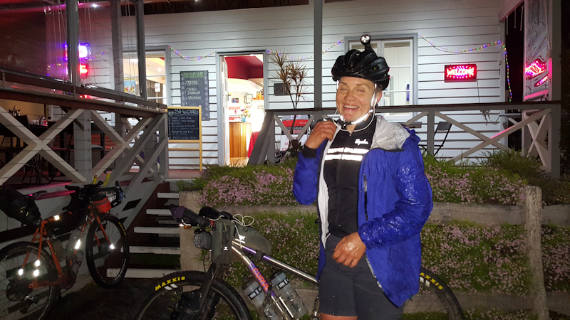
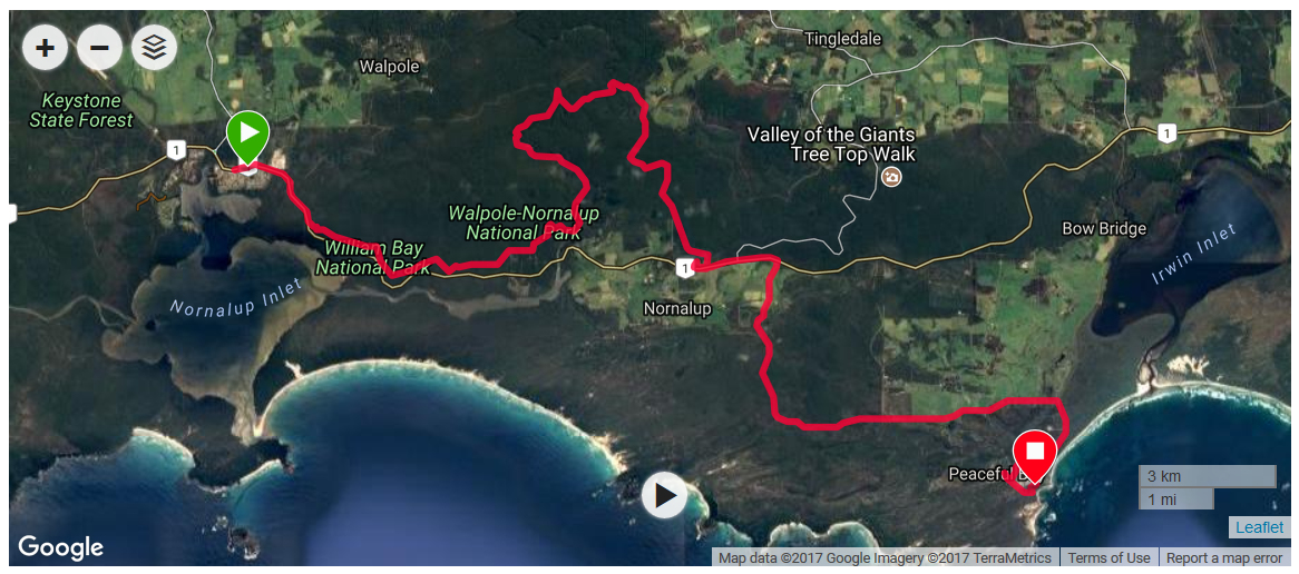
| 25 | 3/9/17 | Walpole | Peaceful Bay | 40.3 | 5h 22m | 3h 34m | 11.3 | 43.1 |
| 26 | 4/9/17 | Peaceful Bay | Parry Beach | 35.0 | 2h 38m | 2h 10m | 16.1 | 41.0 |
| 27 | 5/9/17 | Parry Beach | Denmark | 42.2 | 4h 9m | 3h 6m | 13.6 | 47.0 |
| 28 | 6/9/17 | Denmark | Albany | 74.9 | 7h 1m | 5h 18m | 14.1 | 45.8 |
| Total | 947.4 | |||||||
The average distance travelled each riding day was 37.9kms.
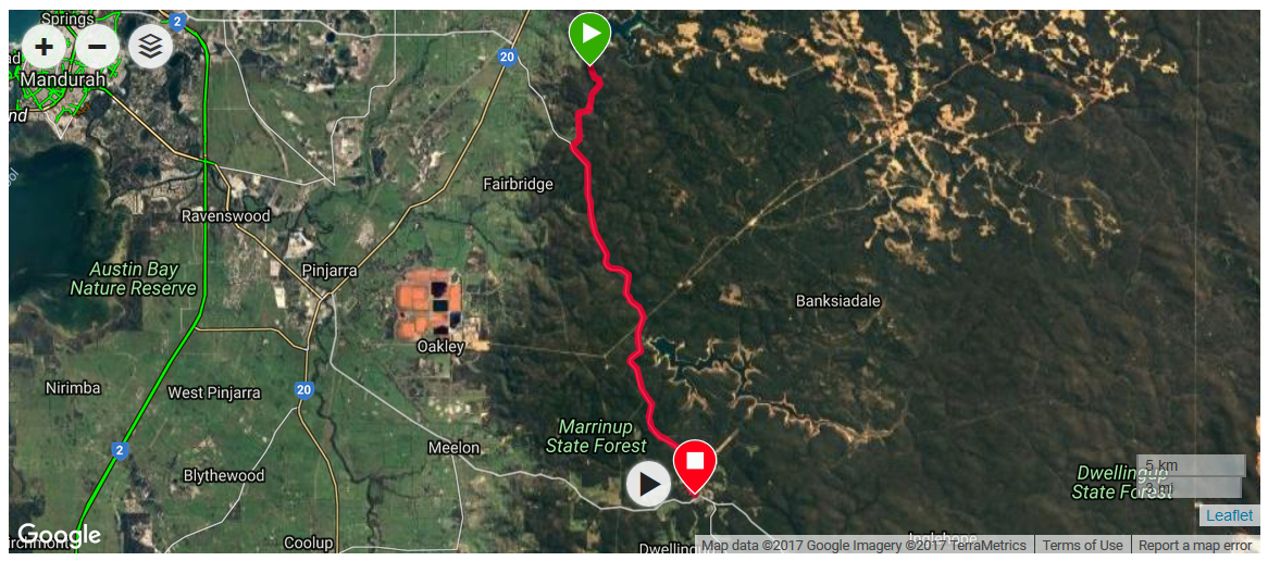
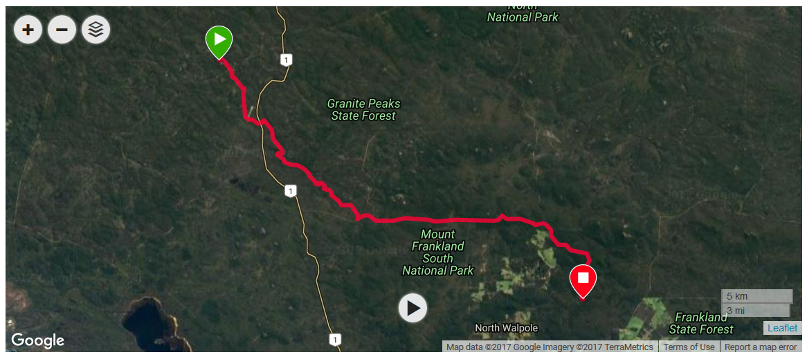
Day 1 - Thursday 10/8/17 - Hazelmere to Mundaring Weir (28.7kms)

Although it rained overnight, the sun was shining in a blue sky - a promising start to the day.
We ate our two remaining bread rolls with a cup of tea for breakfast and started our day's ride at 9.20am.
The first part of the ride was on sealed roads to Darlington, with some uphill sections that were a bit of a challenge for me. Near Darlington we mistakenly took a slightly longer route, involving an even steeper uphill road. As we were pushing our bikes we stopped to say hello to a resident, who asked us where we were heading for. When we told him, he said we were taking a longer route than we needed to and re-directed us to an easier road. We thanked him.
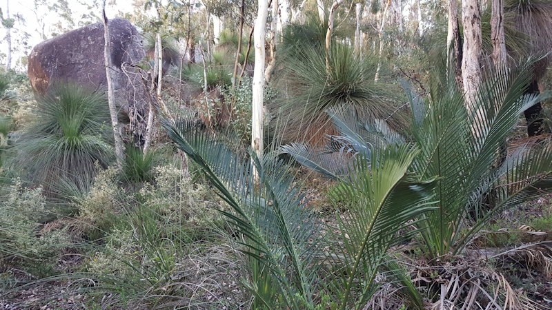
At Darlington Matthew posted some clothes back home that he said he could cope without, because he realised he was carrying too much in his panniers. From Darlington we joined the Heritage Rail Trail to Mundaring, an easy gravel track that sloped gradually upwards through delightful light forest. We saw some red-tailed black cockatoos - the first we had seen - and not seen in Tasmania.
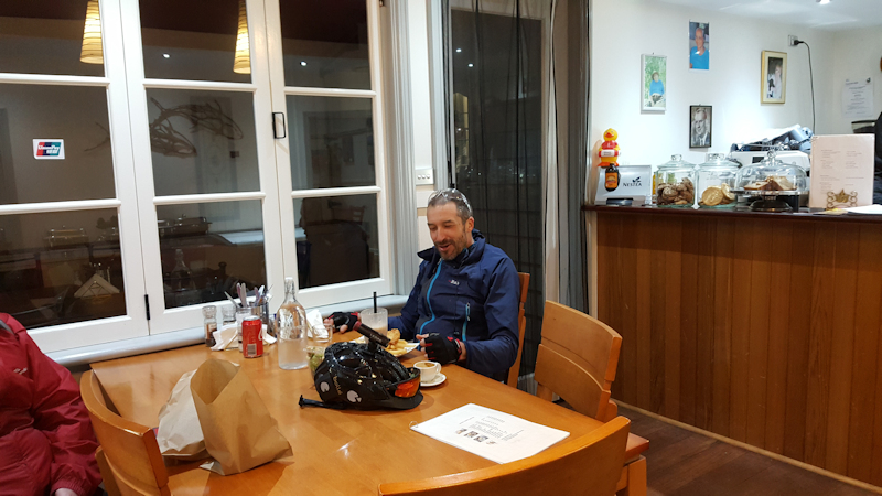
We stopped at Mundaring for about 30 minutes while Matthew bought some tinned meals and bread rolls for dinner before continuing on the first stage of the actual Munda Biddi Trail to Mundaring Weir. This was about 8kms of generally reasonable track, predominantly downhill. We spent a comfortable evening in the Mundaring Weir Hotel room, relaxing and watching TV. We expected Friday's ride to be a tough 30kms ride on difficult pea gravel track.
Day 2 - Friday 11/8/17 - Mundaring Weir to Carinyah Hut (31.4kms)
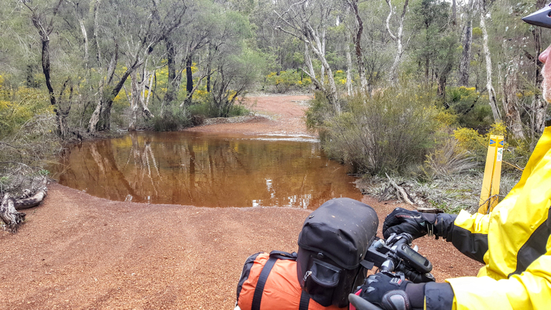
After a very comfortable stay at the hotel, with porridge for breakfast, we were all packed up and ready to leave at 8.45am. This was just as well because, unknown to us, the Mundaring Weir Road was about to be closed for Targa West until about 3.45pm. This would have really been a nuisance for us but we were able to ride the 800m down the road and turned off into the bush before the road was closed. Within the first 5kms we needed to walk our bikes across a flooded creek - not too deep - but it did mean we had wet feet for the rest of the day's ride.
After heading along a track a few kilometres and struggling up steep hills Matthew realised that we were on the wrong track when we failed to see Trail markers and he checked the gps on his phone. At a track junction we met up with a group of mountain bike riders out for a day ride and had a chat before continuing on the real route.
As we rode along the bush tracks we saw more grass trees than I had ever seen before, some with very tall spikes. We stopped for a break at the Dell, a car park for a mountain bike trail hub, and enjoyed the cheese rolls we had prepared earlier in the day. There were many occasions when we needed to push our bikes up steep, rocky parts of the trail - the quality varying greatly from the pea gravel we had been warned about to good, hard gravel tracks. For most of the day we heard the distant scream of car engines and at one point in the afternoon crossed the closed road that Targa West was about to use.
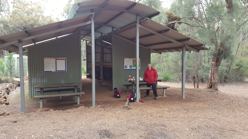
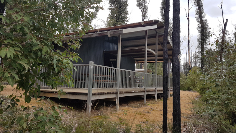
We arrived at Carinyah Hut at 2.45pm - very relieved to see it. There were no other people at the hut so we made ourselves as comfortable as we could, spreading our gear out while we enjoyed a well-earned cup of tea. Dinner was Continental pasta with a cup of hot chocolate a bit later. We buttered our remaining two bread rolls, plus peanut butter, ready for the ride on Saturday.
Even though we were under shelter we erected our tents, just for an extra bit of protection from the expected cold, windy night.
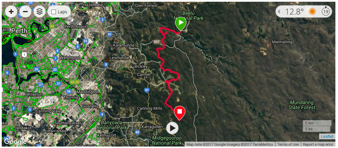
Day 3 - Saturday 12/8/17 - Carinyah Hut to Armadale (23.0kms)
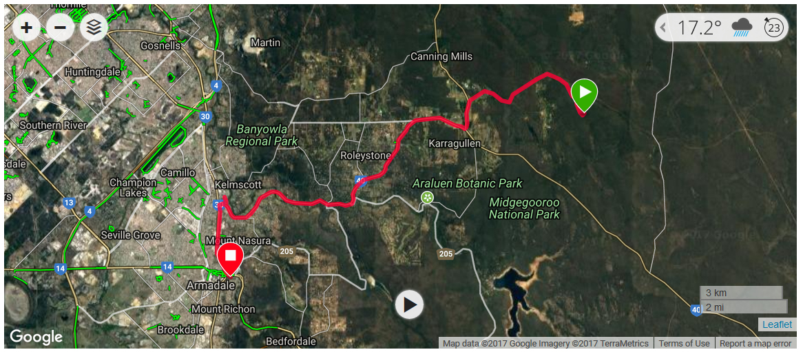
During the night there was torrential rain. Fortunately, our tents, being under cover, kept us protected from the rain and also stayed dry. However, while in the tent, I began to worry about what the rain might be doing to the tracks. Whilst I was able to cope with the rocky track in dry conditions, I was concerned that I might not handle wet, rough rock, particularly on steep descents with a heavy load on my bike.
When I mentioned my concerns to Matthew in the morning - that I was unsure if I could continue and that maybe our ride was over - he suggested we could avoid the immediate problems by bypassing part of the trail to Jarrahdale and using normal roads through Armadale. The aim would be to rejoin the trail at Jarrahdale. This seemed to me to be a good compromise. As we left Carinyah Hut there were several instances where the track was completely covered by water. In these situations, rather than ploughing blindly through the ponds we carefully made our way along the easier side, usually pushing our bikes.
We soon joined a main gravel road, then a sealed road that led us to the Brookton Highway. This took us direct to Armadale, where we booked into the Heritage Country Motel for a relaxing, comfortable night. The plan for Sunday - ride along the highway to Jarrahdale then back to the MB Trail.
Day 4 - Sunday 13/8/17 - Armadale to Jarrahdale (27.3kms)
After a very comfortable stay at the Heritage Country Motel we planned to ride along the South Western Highway and Jarrahdale Road rather than using bush tracks because the weather forecast was for storm conditions with the possibility of 120kms/hr winds.
The ride was uneventful except for an annoying incident at the Shell service station at the junction between the highway and Jarrahdale Road.
We had stopped for a drink and a snack. Matthew asked if the sandwiches were fresh that day and the shop assistant said they had been frozen. My experience of thawed frozen bread is that the bread is still soft, so I bought a chicken, cheese and mayo sandwich. However, when I undid the plastic pack outside the bread was like cardboard and inedible.
When I went back inside to get a refund I was told by the assistant I could only get something else, no money refunded. He refused to give me a refund, offering a sausage roll instead, saying that he had told me the sandwich had been frozen. Just then a lady came into the shop. I showed her the sandwich and she agreed I had to have a refund. After some to and fro bickering it wasn't until I got his name and said I would talk to the Office of Fair Trading that he relented and gave me the refund.
Back on the road, the ride from there to Jarrahdale was generally uphill, but with some flatter parts on the way. We arrived at the B & B accommodation at about 12.00 noon, in rain, and were made very welcome. The owner offered to keep our bikes under cover overnight.
The first priority on getting to our room was to warm up with a hot shower. We then wandered along the road to the pub to check whether we needed to book for a meal later on. It was just as well that we did book because the pub was virtually packed when we walked along for our meal. Probably people escaping Perth for a Sunday drive, we thought.
The plan for Monday - to get back to bush tracks again, to North Dandalup Hut.
Day 5 - Monday 14/8/17 - Jarrahdale to North Dandalup Hut (23.6kms)
We spent a very pleasant evening at the B & B in Jarrahdale. We had the run of the kitchen and the use of a huge bathroom, just a few metres from our room.
The weather forecast for Monday was still storm conditions, so we decided to use the gravel roads where possible to avoid the narrow, rocky trail route.
As we were packing our bikes a torrential rain storm brought high winds and a marked temperature drop. It was fortunate that we were packing under cover. The owners of the B & B had a small Maltese/Shih-tzu dog named Barney. Although not as cute as our dog Topsy was, it was a friendly dog that seemed to enjoy the attention of our presence.
By 9.10am we were ready to set out on the next leg of our journey. We thought it was a good omen that it was not raining as we left Jarrahdale. However, we had plenty of rain and wind to keep us company. I guessed it rained nearly one third of our day's riding.
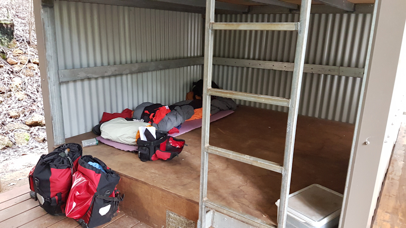
When we did eventually rejoin the actual trail the track was steep, narrow, gouged out by flowing water and very winding. I needed to walk my bike on several occasions, but even then it was far from easy. Before reaching the hut we crossed a spectacular dam and arrived at North Dandalup Hut just after 1.00pm - very relieved indeed to see it as we approached. After setting up our tents under the shelter of the roof and changing into non-riding clothes we enjoyed a cup of hot chocolate and some biscuits and cheese while our wet clothes hung on the ladders and rails in the hope that they might dry sometime before the next morning.
Tuesday's aim is to reach Dwellingup - a small township of maybe 300 residents - about 42kms away.
Day 6 - Tuesday 15/8/17 - North Dandalup Hut to Dwellingup (24.5kms)
There was torrential rain overnight but when we got out of our tents at 6.30am the rain had cleared away. We made a cup of tea and by the time we were ready to leave it was 9.25am.
From the hut, the bike push up steep, loose gravel was a struggle for me and I probably suffered a slight abdominal muscle strain in my stubborn pushing. I knew Matthew would help me but I failed to ask. I needed to change my attitude!
As a result of my struggling, and the very wet track conditions, I felt it would have been too much of an ordeal to religiously follow the trail for the total 42kms. Matthew agreed and we decided to use gravel/bitumen roads for this leg, a distance of about 25kms.
This route took us along Scarp Road then Del Park Road and undulated quite a bit but the road quality was generally very good. I thought it was a good decision.
We booked into the Dwellingup Hotel and had a very welcome, and needed, shower as soon as we had our room.
During the previous couple of days we had become concerned about the amount of methylated spirits we were using when cooking our evening meals and making hot drinks. We were both carrying cookers from our Trangia kits with mini-Trangia bases and windshields. Despite using the flame controlling covers, we were worried about the flaring that occurred in anything but dead calm conditions. We decided that if we could buy a gas stove and gas cylinders in Dwellingup we would be able to do away with at least one of the spirit stoves entirely.
Once we were feeling human again we headed to the Dwellingup Adventures store to see what they might have available. We were in luck and were able to buy a JetBoil Zip stove and two of the larger canisters. This stove was a masterpiece of engineering, with all parts including a small gas cylinder fitting neatly together for stowing away in a single pack.
Back at the pub, I sorted out some gear I had decided was no longer needed - extra spanners, some clothes and my small Trangia cooker - and posted them home via Australia Post. We then headed to the Blue Wren Cafe, where Matthew bought us a toasted sandwich and a drink, the first food for the day. Later we had dinner at the pub and spent the evening watching TV in the unit, while checking out how to use the JetBoil cooker.
Day 7 - Wednesday 16/8/17 - Dwellingup to Bidjar Ngoulin Hut (28.4kms)

We spent a very comfortable night at Dwellingup and were up and about at around 6.45am. Cereal and a cup of tea for breakfast.
By 8.40am we were packed and ready to set out on the next leg of our adventure. There was some rain, as usual, and this, combined with wind, made for uncomfortable riding. However, the actual tracks were better than those we had experienced previously, including some rail trails with more gentle gradients.
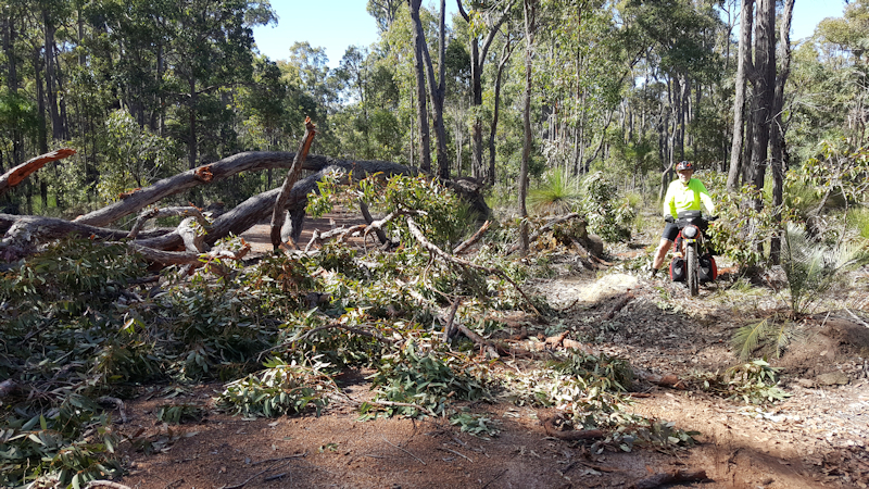
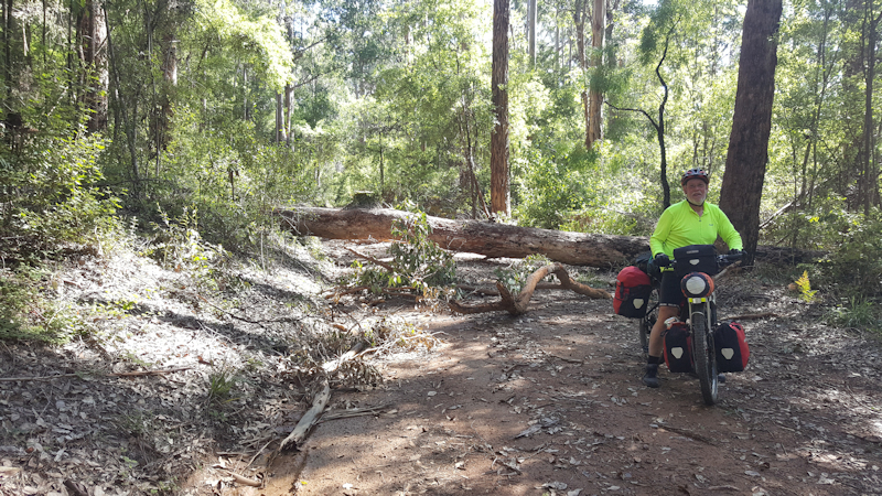
There were some small fallen trees across the track but we were able to lift our bikes over them. We arrived at the hut at about 12.45pm - no other occupants so we spread our gear out more than we otherwise would, hoping the wet things might have a chance to dry out during the afternoon and evening.
We found the new JetBoil stove to be brilliant. My thoughts were that it would make all my other stoves, metho, gas and solid fuel, obsolete. It boiled enough water for two mugs of tea in less than four minutes. Once again, we had set up our tents under the shelter as the wind was blowing dust around and between the two sleeping platform areas.
Thursday to Lake Brockman, if all goes OK.
Day 8 - Thursday 17/8/17 - Bidjar Ngoulin Hut to Lake Brockman (35.3kms)
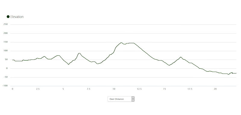
It rained overnight but by the time we climbed out of our tents at 6.45am it had stopped. It remained cloudy however. Breakfast was a muesli bar and a cup of tea and we were ready to leave the hut by 9.30am. We had checked the profile of the 32kms route to Lake Brockman so we knew that the first 17kms was going to be generally uphill.
Initially, the track was quite open and in good condition, even though there were several large fallen trees across the track. For me, these were difficult to negotiate but Matthew helped to drag my bike over them, without having to unload all the gear from the bike. The cold rain was a constant nuisance and made what could have been a reasonably pleasant ride a thoroughly depressing experience.
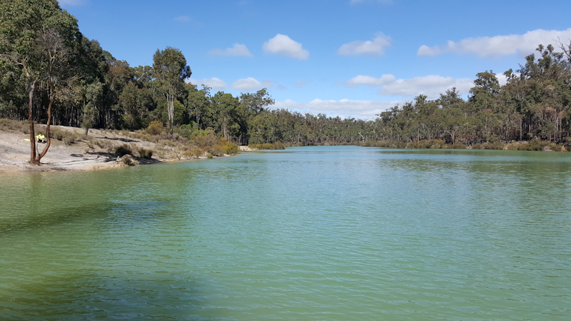
On a couple of occasions we decided to use the wide gravel roads that virtually mirrored the direction that the trail took. We eventually reached Lake Brockman but then needed to skirt around the southern regions of the lake before we eventually reached the caravan park. We were pleased to find out that they had cabins available but the options were: $110 for a cabin with no toilet, shower or bedding and $195 for a cabin with normal facilities.
We were horrified at these extortionate prices. We intended to stay for two nights so that by Sunday afternoon we would be at Collie, ready to seek a bike shop and a medical centre on Monday morning. The bike shop was needed because Matthew had been having trouble with his chain slipping on the second largest rear sprocket and coming off the smallest front chainring. I needed the medical centre so that I could arrange to have my suprapubic catheter changed, using the spares that I had with me for that purpose. As well as these duties, we needed time to dry out our gear so I agreed to pay for two nights in the fully-serviced cabin. The manager apparently took pity on us and gave us a 10% discount. This eased the pain a bit.
During the last few kilometres of this day's ride I had noticed a rubbing of the front wheel. I put it down to the wheel rubbing against the build-up of mud and gravel but, as I was unloading my bike, I discovered the front wheel was loose. I think the constant jarring had loosened the skewer. Needless to say, I tightened it, thankful the wheel had not been damaged - or fallen out.
Matthew bought us dinner at the café later - fish and chips for me and a burger for him. It was a reasonably comfortable evening in the cabin, but no TV to watch, despite the high cabin price.
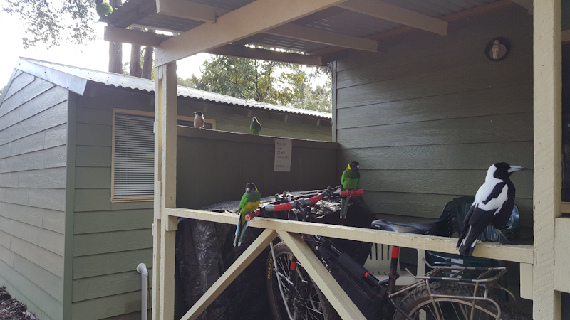
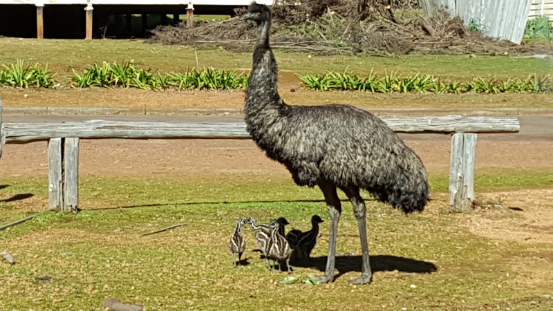
On two separate occasions while riding during the day we saw an emu - one small and the other larger. At the cabin a bunch of magpies and ring-necked parrots ("28-parrots" apparently) swarmed around us, hoping to be fed. We didn't feed them.
Day 9 - Friday 18/8/17 - Rest Day at Lake Brockman
We spent the rest day doing washing and drying, cleaning our bikes and wandering around the caravan park, looking at the lake etc.
Day 10 - Saturday 19/8/17 - Lake Brockman to Yarri Hut (33.0kms)
A good, early start at 8.35am in calm, sunny conditions. For once, no rain. Initially, we travelled on a wide, gravel road and soon turned off onto Palmer Road. We took this road to try to reduce the total travel time to Yarri Hut. Palmer Road turned out to be an old section of the Munda Biddi Trail, superseded by the new track. As it headed upwards, it was a running creek with much rain run-off finding its way down the track.
At the junction with Myles Avenue we stayed on the gravel road to avoid the flooded trail. The last 2kms were back on the trail, an easy downhill run except for a giant tree that had fallen across the track. This needed some delicate carrying (mostly by Matthew - thank you) over the tree to avoid damaging chainrings and derailleurs.
We reached the hut at 12.10pm. There were no other visitors so once again we were able to spread out our gear. For this night we decided to use the covered camping platforms, with just our sleeping mats and sleeping bags.
After changing into camp clothes we ate the sandwiches I had made at Lake Brockman and had a cup of tea afterwards. Noodles with tuna for dinner.
Next day destination Collie, for me to have a catheter change at the hospital and for Matthew to find a bike shop.
Day 11 - Sunday 20/8/17 - Yarri Hut to Collie (40.3kms)

This was a good day's ride. First of all this was because it was the second day in a row without rain and, second, because the quality of the trail was better than what we had experienced before.
That does not mean it was all plain sailing, so to speak! There were still some deep ponds of water where the trail was in a dip. On these occasions we were able to either ride along the edge or walk along the edge with our bikes in the water.
We never deliberately rode through the middle of ponds that covered the trail. I thought on this day I might be improving my ability to stay on my bike while negotiating rocky, sandy, loose gravel. But it was still never easy for me. On a couple of occasions we used main roads but we were relieved to be back on the trails when traffic passed us too close for comfort.
After riding for over 40kms it was a relief to reach Collie. We stopped at Collie Motel then had to wait for at least 30mins before the after hours phone was answered. As a consolation prize for waiting we were offered a family room. We were very comfortable.
Because I was concerned about my catheter possibly becoming blocked later in our ride, I rode to the Collie Hospital and was able to have my catheter replaced with a new one that I provided. This was done at no cost to me, for which I was very grateful. Dinner was a Big Mac meal while watching TV during the evening.
Rest day in Collie on Monday to get bike issues fixed.
Day 12 - Monday 21/8/17 - Rest Day at Collie
This was a very relaxing day. Having sorted out my catheter on Sunday, we did some shopping, visited the bike shop and made up a parcel of items we expected to not need for the remainder of our ride to send back home.
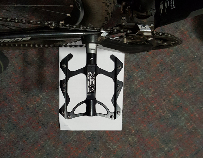
At the bike shop Matthew's bike needed a derailleur adjustment, not a new cassette. We both bought new flat pedals to replace the double-sided flat/clip pedals we had been using. The reason for my change was that I was wearing normal sneakers, without cleats and needed to turn the pedals over so that I could use the flat sides. Sometimes there was no time for me to do this, particularly when I was starting off going uphill. Matthew had found he needed to be able to move his feet around on the pedals more than cleats would allow, so he needed to change his pedals to make it easier on less than perfect knees.
I bought some new gloves and two replacement chain links in case of a chain breakage. We then topped up our grocery supplies for the following two days and cleaned our bikes. Subway meal for dinner.
During the evening Matthew worked out that, for us to finish the ride in time to catch the pre-arranged shuttle service back to Perth, we would need to ride about 41kms per day, without any more rest days. We both felt this would be achievable because we had been told that the trail conditions were easier as we travelled south and there was a good chance the weather would improve. Also, I felt fitter and more able to cope with adverse trail conditions.
Day 13 - Tuesday 22/8/17 - Collie to Nglang Boodja Hut (36.1kms)
Another comfortable night at Collie. We were just about to leave the motel when Matthew discovered the bolts that held the rear rack to the bike needed to be tightened. However, the bolts were difficult to tighten and Matthew thought the bolt on one side might break. Fortunately, I had some spare 25mm long bolts so he was able to use one of them after putting some grease on the threads. It seemed to work OK, but was a warning that we needed to check our bikes thoroughly at the end of each day's ride.
It was a very pleasant ride out of Collie towards Allanson and for the first 20 - 25kms the trail was wide with a good gravel surface.
We rode past the school at Worsley, next to private property, then entered forest areas where the track became very narrow, with overhanging branches that drooped even lower than normal in the rain that lasted for maybe 30mins. I did not cope very well with the switchbacks that the notes warned us about and I needed to walk the bike down around the hairpin bends.
We used a gravel road for a short distance to avoid a particularly difficult section of the trail and stopped for a few minutes at Honeymoon Pool picnic grounds for a sandwich and a drink.
Normally, this would be a very pleasant spot next to the Preston River but, on a cool day with light rain, it was slightly depressing. From there we pushed our bikes up a steep one-way road before turning off onto more downhill switchbacks - more walking around the sharp bends for me.
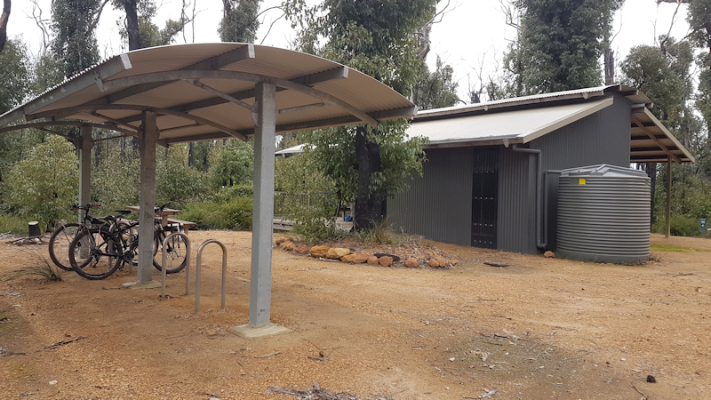
There was a gate at the bottom of the hill and from there it was only a few kilometres to the small, but very comfortable, hut.
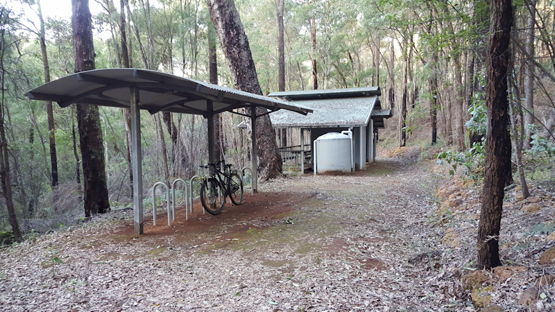
No other visitors as at 3.00pm. After unpacking and changing clothes we enjoyed the afternoon sun in a calm forest environment. We used the platforms with our sleeping mats and bags this night.
Day 14 - Wednesday 23/8/17 - Nglang Boodja Hut to Donnybrook (41.2kms)
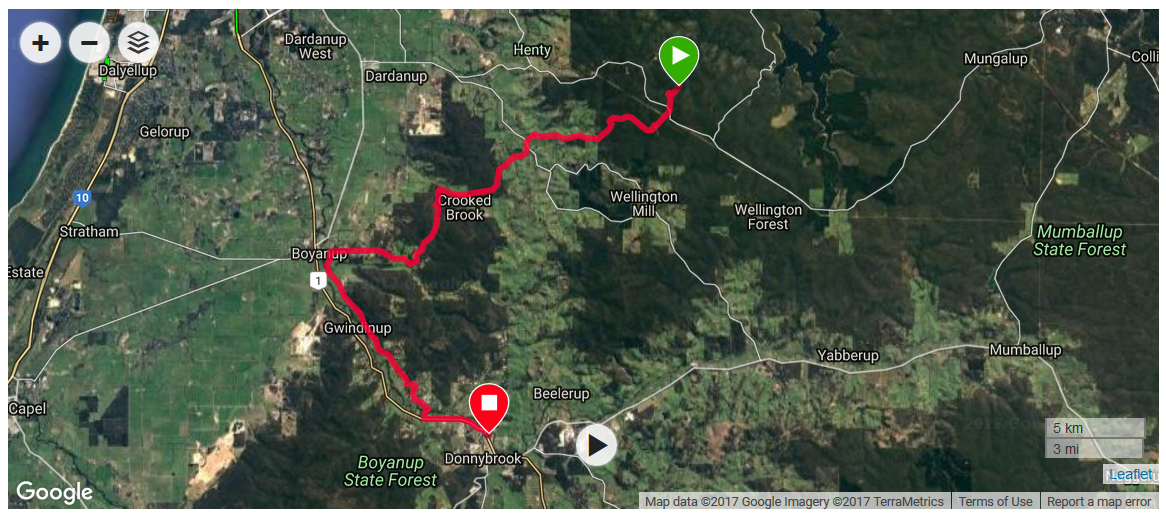
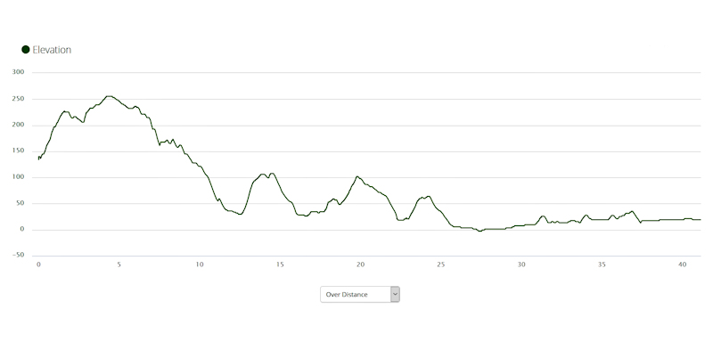
It was a very cold night at the hut but we were snug and warm in our sleeping bags on the platforms. The weather was kind to us, warm and sunny, as we left to push our bikes up about 2kms to level ground. The trail was a mixture of good gravel, narrow MTB track, bitumen road and a major highway. We stayed on Richards Road for some time, before turning onto Ferguson Road then, almost immediately, onto Ironstone Road. From there we took Boyanup-Ferguson Road then Joshua Creek Road. This led us eventually to the South-Western Highway and into Donnybrook.
We reached Donnybrook at about 1.15pm and booked into the Donnybrook Motel - a very tidy room with everything we needed. After a shower and change of clothes we cleaned our bikes then walked along to a bakery for a snack and a drink.
At the Tourist Information Centre Matthew bought a map that showed the remainder of our ride, down to Albany. We bought pasta at the IGA supermarket for our dinner back at the motel and some snacks for the evening. The motel owner could not have been more helpful, offering to safely store our bikes in a locked shed overnight.
Thursday's ride will take us to Jarrahwood, where there is a hut and a community house or, if we are feeling fit and the track is good, on to Nannup. This would be our longest distance of the trip if it were to happen.
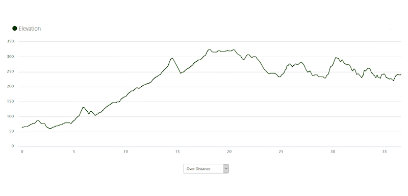
Day 15 - Thursday 24/8/17 - Donnybrook to Nannup (71.4kms)
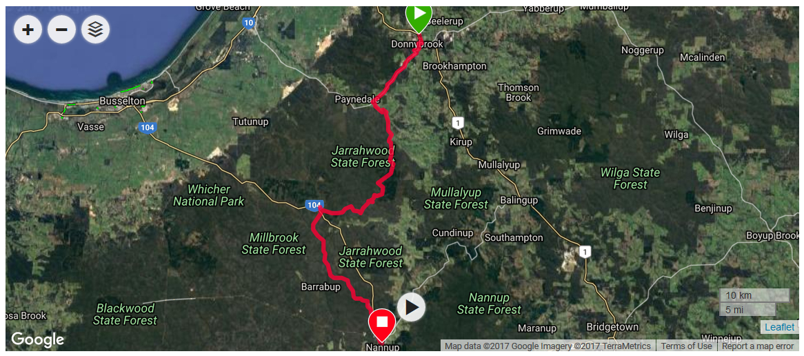
Leaving Donnybrook we faced a gradual uphill ride for a few kilometres before turning off the sealed road onto a good gravel road (Vernon Road). The trail then became a serious single track MTB trail, on which I needed to walk my bike for about 200m on the rocky uphill section.
After about 20kms we stopped on a good track near a large dam near Lidel Road with aqua-coloured water and ate our lunch of bread rolls with jam and peanut butter.
While we were relaxing a lone rider arrived, riding the trail from south to north. He said his name was Mark C (as per his log book entries). He told us about very bad track conditions further south and where we would find good accommodation and meals. He had a backpack and all his gear loaded on the back of the bike, including rear panniers, but no front panniers. He also had a solar panel attached to the pack, but it was facing away from the sun. He said he could count the number of trees across the track in double figures!
We all wished each other the best of luck and continued on our way. From there the tracks and road to Jarrahwood were a very good quality and we made good time.
As we were riding towards Jarrahwood Matthew asked me if I thought it would be possible to ride on to Nannup along the 26kms rail trail. Although this would make a total for the day of 71kms I thought it was too good an opportunity to miss - to make up an extra day's travel. Being a rail trail, I thought it unlikely that there would be steep hills to worry about.
The rail trail was good gravel but I initially had some trouble staying on the narrow (30cms) usable track with steep cambers and soft gravel each side. I became very tired at the constant uphill slope of the trail, needing breaks every 5kms or so, but the trail eventually levelled out and dropped towards Nannup.
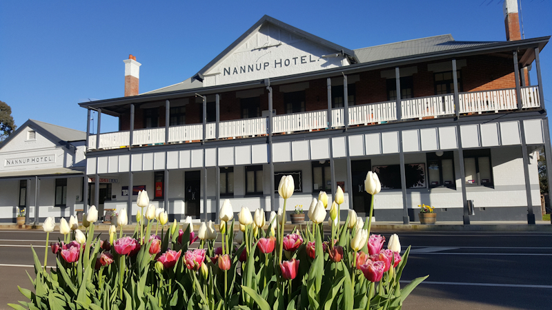
Matthew paid for a unit at Nannup Hotel; fish and chips for dinner and a very comfortable evening, watching TV, munching snacks and writing up our notes.
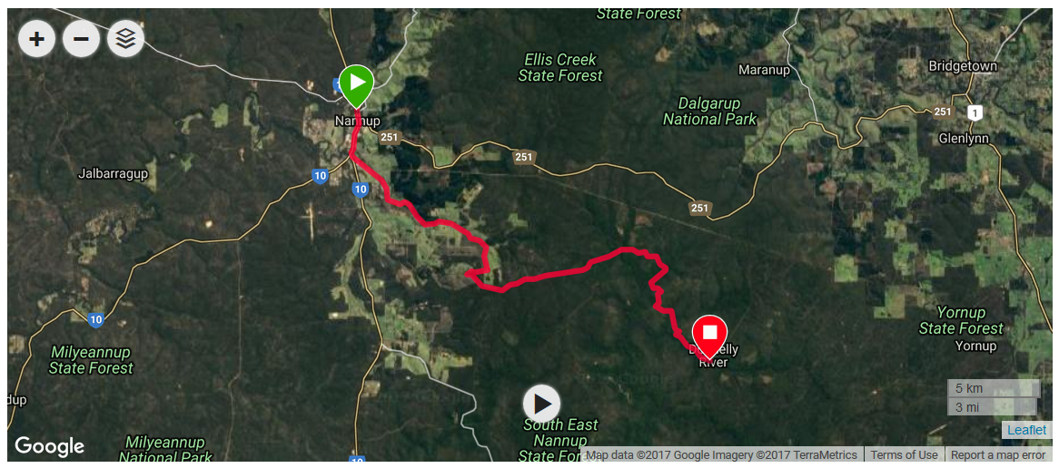
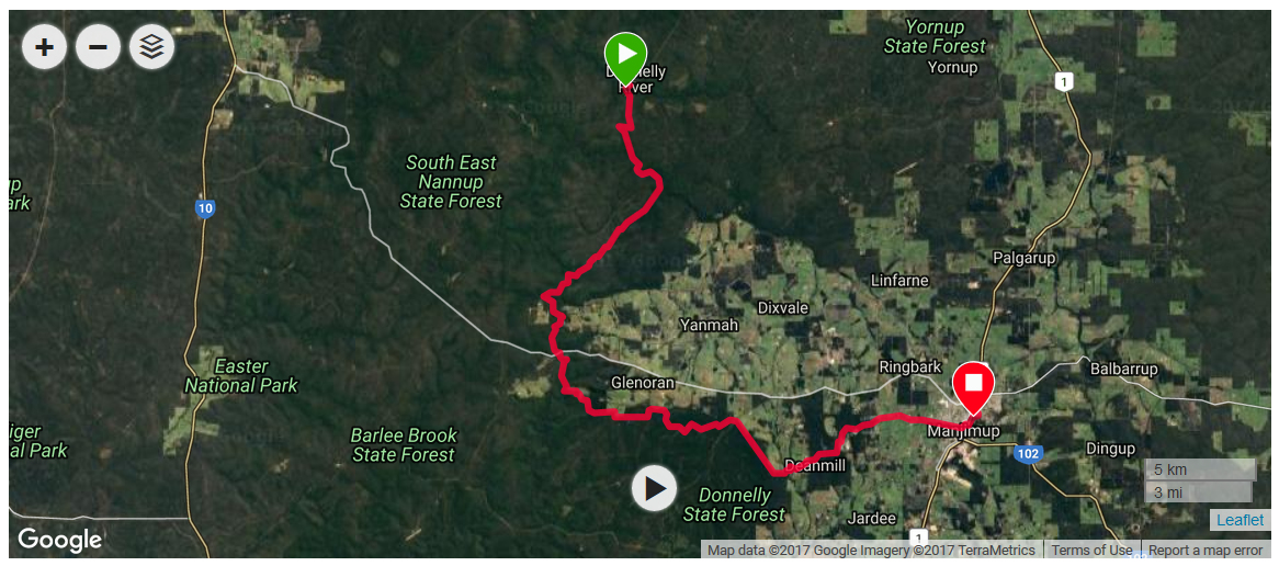
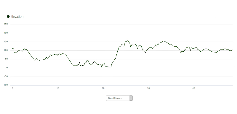
Day 16 - Friday 25/8/17 - Nannup to Donnelly Mill (36.6kms)
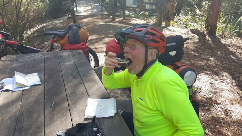
When we saw Mark C on Thursday he said the hill out of Nannup went on for about 13kms. He was not wrong. The encouraging thing about the climb was that it wasn't so steep that we needed to push our bikes. After a short, exciting descent, we turned off to a good gravel road. At a crossroad we stopped for a few minutes and, sitting on a log, ate our cheese and bacon rolls that Matthew had bought at the Nannup Bakery. As soon as we started off again, we noticed a picnic area that had seats and a table that we had missed by stopping at the crossroad.
We soon turned off into rough, winding bush tracks that, on some sections, I needed to walk my bike. There were some twisty descents that really were a lot of fun to ride - quite exhilarating.

We eventually reached the Donnelly River - a delightful forest creek - where Matthew unexpectedly produced two mint slices that we ate at a picnic table. What a treat!
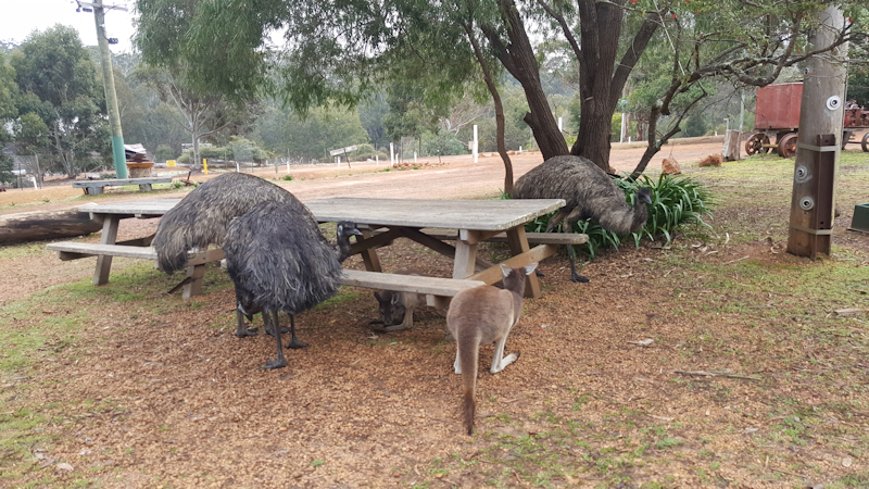
It was only a short distance to Donnelly Mill, where we were welcomed at the shop by many large kangaroos and emus.

We booked into bunkhouse accommodation in the old school (the only occupants) at $25 each. Included were a kitchen, shower, beds, toilet and couches to relax. We were able to spread out our gear in the bunkhouse as there were no other people to occupy the spare four bunk beds. The bunks were flimsy, rubbish Ikea bunks that threatened to collapse with any unnecessary movements.
We ate in the café later - curry pie for Matthew, lasagne and salad for me.
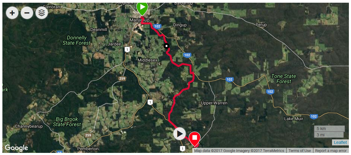
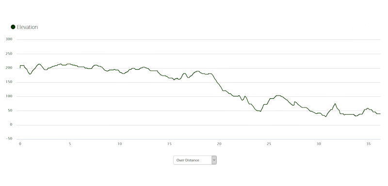
Day 17 - Saturday 26/8/17 - Donnelly Mill to Manjimup (48.6kms)
At 8.20am we were waiting at the store/café to buy our breakfast - waiting along with 12 kangaroos and four emus, plus seven chicks who were also queuing for breakfast. Matthew bought us a toasted sandwich and some cheese and pickle sandwiches for lunch. However, we found it was a mistake to eat outside the café as the collected wildlife crowded around us for food. One of the emus actually pecked at Matthew's sandwich so we took ourselves back to the bunkhouse and sat outside while we ate our breakfast in comfort.
Out of the total distance of 48kms to Manjimup the first 23kms were very difficult for me, especially struggling to walk the 2kms of uphill zigzags that led to our lunch break at Karta Burnu Hut. Matthew did very well by riding all the way up this particular nasty hill.
After about 28kms we encountered an area of devastated track, where a farm dam that was close to the track (Coutt Road/Boundary Road area) was overflowing and the outflow, combined with gouged tracks from heavy equipment, had turned the track into a muddy quagmire. Matthew took some video footage of the damage.


The remainder of the ride was uneventful, except for the final kilometre, when Matthew discovered his rear wheel had a puncture. I suggested we push both bikes to some nearby accommodation but Matthew insisted on changing the tube on the wide walking track that we were on.
While he was busy fixing his bike a lady (Leanne), who was out for a walk, stopped to chat. As no bike shops would be open on a Sunday for Matthew to buy a replacement tube, Leanne kindly offered to give Matthew the tubes from her MTB that she wasn't using. Having fixed his bike, we followed her to her home close by and, as the bike was a 29er Matthew took the tubes out. Leanne did not want to be paid for the tubes but I gave her $20 for the tubes and thanked her for her trouble, hoping she would buy new tubes and finally get to use the bike. We booked into a nearby motel and relaxed in the room during the evening.
We phoned ahead and booked into the Quinninup Caravan Park for the end of Sunday's ride.
Day 18 - Sunday 27/8/17 - Manjimup to Quinninup (36.2kms)
The included Continental breakfast, provided as part of the room fee, was absolutely wonderful. There was an impressive array of jams, cereals, fruit, juices as well as butter, three types of bread for toast and tea and coffee.
We left just after 9.00am and soon found ourselves on a few short back tracks before joining a good gravel road away from Manjimup.
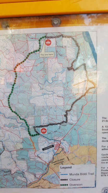
There were no incidents until we reached the junction of Sherman Road with Peppermint Grove Road. There was a large sign stating that the Munda Biddi Trail was unavailable for the following 22kms because of timber harvesting operations and a large detour was necessary. We wondered whether any timber harvesting operations would be conducted on a Sunday but decided we should use the detour, just in case.
As soon as we had started on Peppermint Grove Road there was an immediate screaming fast descent on a wide, rough gravel road. For me this was a hair-raising experience as I was almost out of control - but still wanted to enjoy the speed of the descent. Everything worked out well.
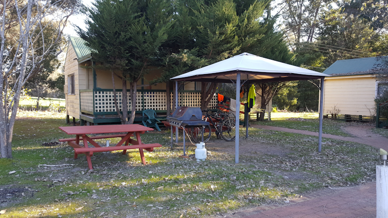
We finally reached Quinninup via some rough back tracks and were shown to our accommodation, which was a small cottage, quite old but very comfortable with a verandah, table and chairs outside. During the afternoon we were entertained by a dozen magpies, with maybe seven or eight kangaroos grazing on the grass some distance away.
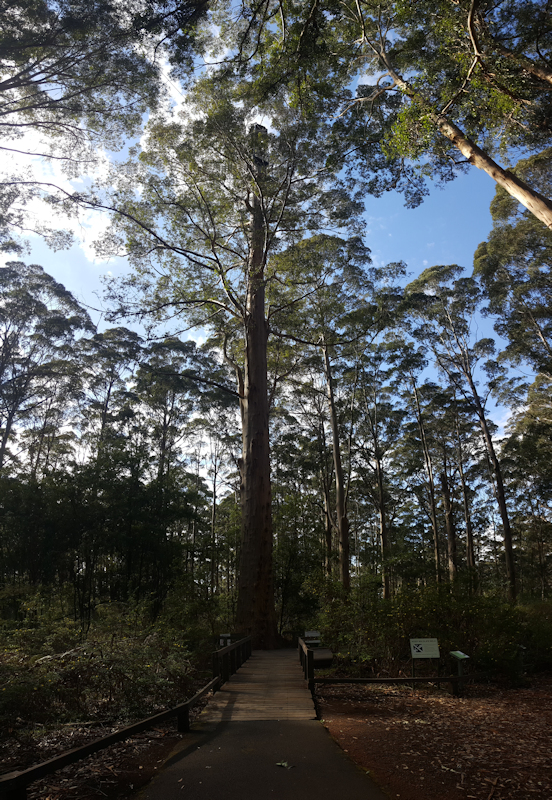
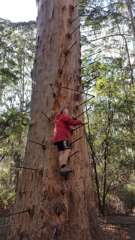
Monday's destination - Pemberton and the Gloucester Tree. This karri tree is a fire lookout with steel rods set into the trunk to enable people (fire observers) to climb up the 56m to the lookout platform.
Day 19 - Monday 28/8/17 - Quinninup to Pemberton (38.3kms)

Another tasty breakfast - this delivered to our door the previous evening in a large plastic container ready for morning. Included in the box were bacon and eggs (for us to cook), bread, margarine, apricot jam, porridge, tea, coffee and milk. A very comfortable stay.
Soon after leaving Quinninup we left the road and zigzagged along a single-track trail that then ran parallel to Wheatley Coast Road. We stayed on the actual trail for this day's ride, except for the last 5kms which were on the Vasse Highway into Pemberton. Matthew paid for a comfortable cabin at the Pemberton Caravan Park, where we had everything we needed.
After our showers, we did a load of washing, then walked up the hill to IGA to get some supplies for the evening and for the huts to come in the next few days. We also called in to the general store where Matthew was able to buy some spare tubes for his bike. [The tubes that Matthew was given by Leanne at Manjimup were so old that, when he was taking them off her bike, the tubes had stuck to the insides of the tyres. There was a good chance they had perished over time.]
Dinner at the Pemberton Great Western pub - barramundi, chips and salad for me and pasta for Matthew - then back to the unit to relax for the evening.
Day 20 - Tuesday 29/8/17 - Pemberton to Northcliffe (45.3kms)

We left Pemberton Caravan Park just on 9.00am and were faced immediately with a nasty climb up to the town centre, then a continuing arduous climb away from Pemberton as the road turned right, left, right, left and right again before heading the 3kms to the Gloucester Tree. I knew Matthew would want to climb the 165 steel rods that spiralled up to the lookout platform but I was still suffering from the exertion of riding up the hill out of Pemberton and was concerned that my knees might give out part way up or down the tree. As I expected, Matthew went up, with a lady who had arrived by car, also with the aim of climbing the tree.
When we left the Gloucester Tree we had a wonderful downhill run on a series of zigzags on the narrow track. Between each two hairpin bends there were humps and dips that made very interesting and exciting riding, especially as we were brushing through overhanging fronds and thin tree branches. The only drawback on the descent was that there were several fallen trees on the track that needed to be struggled over as we went.
After about 27kms we turned off Orchid Road and rode a short distance on Wheatley Coast Road. From there we turned steeply onto a track under power lines. Unfortunately, I lost concentration and failed to notice a sign that directed me to turn off to the right after about 200m (where Matthew had turned off ahead of me). I continued on downhill under the power lines until I came to a junction of Cosmo Road and Cederman Road, with no signs to indicate where I should go. I should have immediately retraced my route. Instead, I had a couple of scratchy phone calls with Matthew asking me where I was. In between telling him I was close to the highway and blowing our whistles I eventually realised I needed to ride back up the hill that I had come down. I reached Matthew and apologised for my mistake, promising to be more vigilant in future.

As had happened many times before, we found we were being sent on side trips using narrow, single track trails, only to rejoin the road we had already been riding on a short distance away. We became convinced this was done as much to justify the overall Munda Biddi Trail distance of 1,000kms as to give riders a true bush experience. Most of the time we did enjoy the "diversions" anyway.
We eventually reached Northcliffe at about 3.30pm and booked into the Northcliffe Hotel, with shared bathroom facilities. After a pleasant fish and chips/pasta dinner we relaxed in the guest lounge for the evening.
Day 21 - Wednesday 30/8/17 - Northcliffe to Yirra Kartta Hut (42.2kms)

There were no breakfast facilities at Northcliffe Hotel so we packed and left quite quickly, heading for the nearby café where Matthew bought us toasted sandwiches and drinks.
We enjoyed riding on a sealed road away from Northcliffe (Boorara Road) that lasted for a few kilometres before we joined Dean Road then Nelson Road. These were reasonably good gravel roads that eventually led us to Bull Road, quite close to the Yirra Kartta Hut. We had decided to use roads in preference to rough bush tracks as we needed to cover close to 50kms to the hut. However, apart from missing two parts of the trail, the Munda Biddi Trail actually was on good gravel roads for much of this day's ride.
On Bull Road we met two Parks people driving in a VW ute. They stopped to say hello and Matthew was able to tell them about the fallen trees and overflowing farm dam we had encountered on our ride. As usual, this hut had everything we needed.

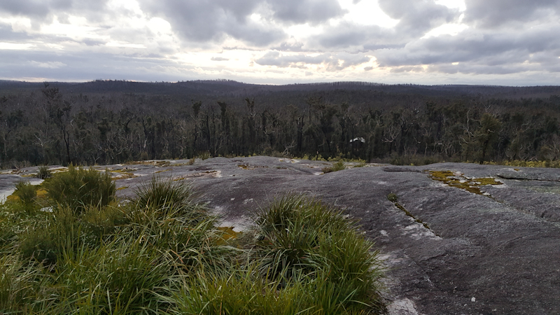
It was a mild afternoon and evening and towards dusk we walked up the granite dome that was close to the hut. An early night (as usual for hut life) and looking forward to riding to the next hut.
Day 22 - Thursday 31/8/17 - Yirra Kartta Hut to Kwokralup Beela Hut (41.5kms)
The forecast for Thursday was for showers. Just before 3.00am the first shower arrived, with two more short periods of rain before we got out of our sleeping bags at 6.30am.
We had a cup of tea for breakfast and I forced a nasty muesli bar down. Matthew did not fancy one, so did not eat.
On the road/track by 8.35am, we had a mixture of good gravel, 4WD gravel and single-track trails. After about 18kms, while riding on an overgrown 4WD track we came across a huge tree that had fallen across the track. The broken branches extended for at least 10m away from the track. The only way past was to clear a rough path by moving many large branches out of the way.
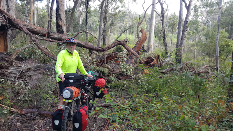
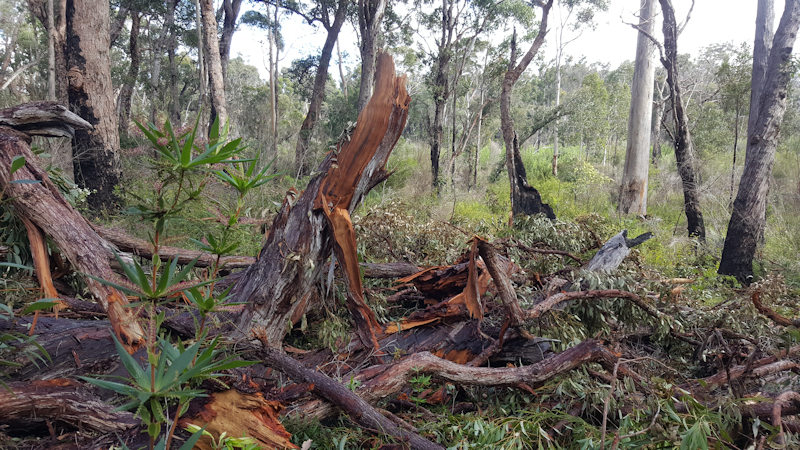

There were several other occasions when Matthew was magnificent in being able to heave our bikes over fallen tree trunks, often over 1m in diameter. If I had been by myself I am certain I would have had to unload my bike before getting everything over the trees.
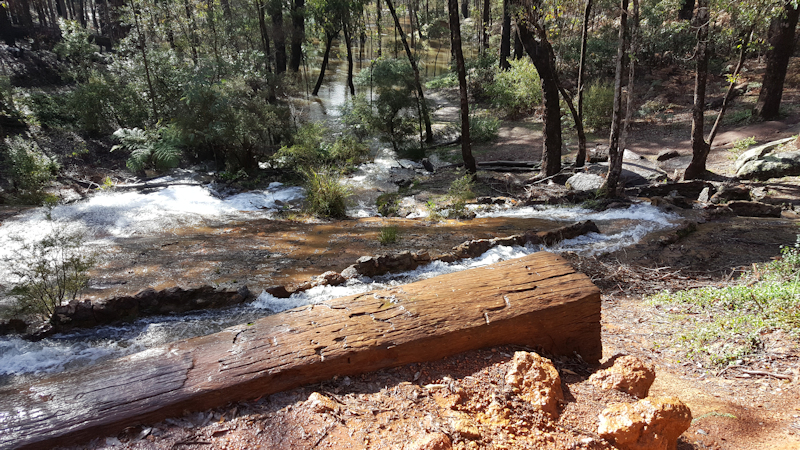
At Fernhook Falls, near Beardmore Road, we enjoyed a Boost chocolate bar and walked down to have a closer look at the falls.
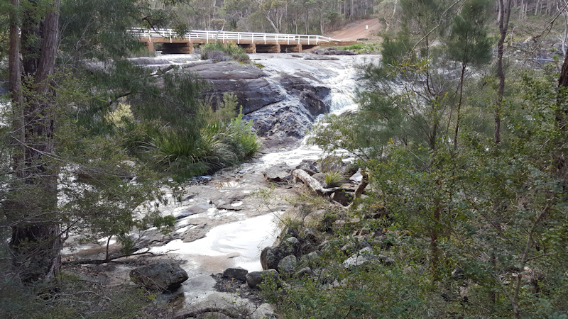
There were several tourists at the falls so we swapped experiences with them before continuing the ride. Obviously, the falls were on a river so there was the inevitable steep climb away from the bridge over the river. Just past the bridge we stopped for a photo opportunity but Matthew, who was taking a video at the time, slipped on the wet rocks and landed hard on his right knee. No serious injuries, but it reminded me of a similar fall he had while walking on wet rocks at the Mount Paris dam in NE Tasmania a few years ago. That time he fell flat on his back. It looked serious but, from memory, apart from being shaken up, he was OK.
Beardmore Road was a very frustrating road to ride on because the showers had softened the gravel surface and made riding very slow, even on the level or down slopes. It was like riding through treacle. We eventually reached some 4WD tracks that made for easier riding, right up to when we turned off to the hut.
After changing into non-riding clothes and organising our sleeping arrangements on the platforms we made our normal cup of tea and relaxed, with no other visitors at the hut. Dinner was noodles, tuna pieces and a slice of bread with margarine and peanut butter.
During the afternoon we had looked at the map for Friday's ride and noticed that about 1km after leaving the hut the trail took a large 5kms looping "detour" around what looked like a creek gully. However, there was a straight track that joined the track we would eventually be on. We assumed there must be a very good reason for the trail route to not use the straight track so we decided to follow the trail map instead.
We made a cup of hot chocolate during the early evening and were into our sleeping bags by 7.30pm for another well-earned 11-hours rest.
Day 23 - Friday 1/9/17 - Kwokralup Beela Hut to Walpole (22.1kms)
There were showers during the night and the forecast for Friday's ride was for possible thunderstorms in our area. We packed quickly and were out on the wet trail by about 8.30am, not raining but with very wet vegetation to push past. As we had intended, we ignored the straight track across a creek gully and rode the 5kms loop. As we passed the end of the short cut we looked along that track and noticed the vegetation was very thick indeed - maybe impassable for a fully-laden bike but at least a mighty struggle.
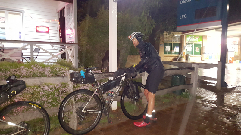
As we were on Copeland Road, a wide gravel road, the riding became a bit easier, despite the road being soft. Knowing about the forecast for thunderstorms, we decided to try to get to Walpole by the most direct route. When Copeland Road joined North Walpole Road we decided to stay on it, rather than take side tracks as indicated on the trail map. That is when the rain came down in a torrential downpour, accompanied by a very cold wind. We kept going but our hands and feet were feeling very cold. Fortunately, our rain jackets protected our bodies from the driving rain.
This was one day when we were really glad that the ride was over quickly and we arrived at Walpole before 10.45am, still in rain.
We immediately headed for a café and enjoyed a late breakfast before booking into the Treetops Motel, just down the road. We had a beautiful room, naturally with everything we needed. So much so, that we paid for a second night so that we could dry out our clothes and maybe have more settled weather for the remaining four or five days of our adventure.
During the ride Matthew had heard a grating sound that was coming from his front hub so we bought some bearing grease and silicon spray from a local hardware store. We cleaned our bikes as thoroughly as we could that afternoon and cleaned the bearings and repacked Matthew's front hub.
For our evening meal I had fish and chips (five fillets!) and Matthew had a pizza.
Day 24 - Saturday 2/9/17 - Rest Day at Walpole
The reason for this rest day was because we believed it was going to rain again, with the possibility that the following two or three days might show an improvement in the weather.
We rode our unencumbered bikes along to the bakery for some breakfast then continued riding around the roads of Walpole, down to Inlet beach and some way along the Munda Biddi Trail on a nice, wide gravel pathway.
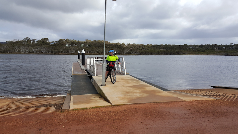
Back at the motel Matthew discovered that a major bike race was starting this day - The Race to the Rock - from Albany to Uluru, a distance of over 3,000kms totally unsupported. Of the eight original starters, seven had made progress along the Munda Biddi Trail, with one rider delayed needing a replacement wheel. We were able to check their progress via their trackers and at about 6.00pm we walked a short distance along the trail and waited at the information area for the leader, Adam Rozsa, to arrive.
We took some photos of his arrival and at the café where he stocked up on food and drinks. The second rider, Sarah Hammond (the eventual winner of the race), arrived about 30mins later with the third rider, Kevin Benkenstein, a further 15mins away.
Later in the evening, about 10.45pm, we saw on the tracker that they had passed the next hut - Kwokralup Beela - and were still riding on the trail. I didn't understand how they did it.
Sunday's ride for us to Booner Mundak Hut, a distance of about 50kms.
Day 25 - Sunday 3/9/17 - Walpole to Peaceful Bay (40.3kms)
Matthew made my day by producing a Father's Day card for me and wishing me a Happy Day. I was very touched by this gesture, especially as he had bought the card some three weeks earlier.
Half a bread roll with peanut butter each and a cup of tea for breakfast and we were ready to go by just after 8.30am.
We rode along to the café and saw two race riders, James Deck and Jules, who were preparing to leave on the next leg (maybe 250kms) of their race. It looked as though Jules was going to have a lot of trouble as his rear derailleur was being held together by an allen key and cable ties, a bolt having snapped. This apparently happened late the previous evening on Day 1 and forced him to walk the bike about 20kms to Walpole.
Our ride continued in cold, rainy conditions, with soft gravel tracks and steep climbs occurring frequently. We persevered until the grinding noises from our bike bottom brackets and chains meant we needed to re-think where our destination for the day was going to be. If we followed the trail we would be heading for three days in the forest with no possibility of any meaningful bike repairs if they were needed. As well as this prospect, we had heard about Middle Road being a particularly unpleasant road. We stayed on the Trail past Sappers Bridge then aimed to get back towards formed roads.

Rather than continue along bush tracks we decided to take the South Coast Highway for about 2kms and head south to Peaceful Bay, where there was a caravan park (tent sites for us), a café and a good camp kitchen. At about 1.5kms along the highway we noticed the sign to the Denmark Nornalup Heritage Rail Trail and turned off along that, to get some respite from highway travel. However, after about 500m the trail led us back to the highway, with no obvious continuation on the other side of the road. Just as we left the highway we sheltered for a few minutes under a huge pine tree. Matthew wished me a Happy Father's Day again and produced two caramel slices that we ate while resting under the tree.
After paying for the tent sites (2 x $15) we started to unpack in the camp kitchen where we met a Bibbulmun Track walker who was walking part of the track from Northcliffe to Albany by herself.
We had a wonderful, powerful shower in the toilet block then a fish and chips dinner from the café, eaten in the camp kitchen. There were cheese and biscuits during the evening while chatting to the walker, then an early night in our tents by 8.00pm.
Day 26 - Monday 4/9/17 - Peaceful Bay to Parry Beach (35.0kms)


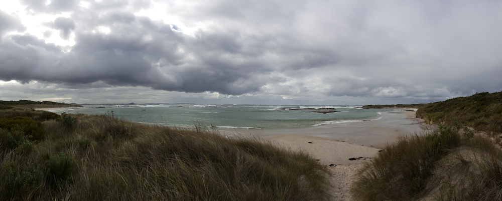
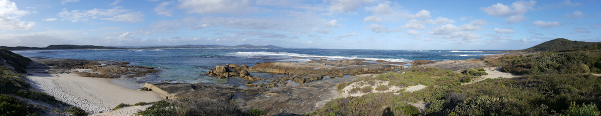
There was some rain overnight, so we needed to shake out our tents in the morning to try to get rid of as much moisture as we could before packing up. Before we left Peaceful Bay we walked down the short distance to the beach to admire the beautiful views out to sea.
This day's ride was almost entirely on sealed roads, first taking us back to the South Coast Highway, then down the Parry Road to our destination at the camping grounds. The camp sites here were in a lovely, leafy environment just a few metres from the water at Parry Beach.

When we arrived at the beachfront there was a Bibbulmun Track walker (Hugo) relaxing at a picnic table. We chatted for a while and I offered him a new, small LPG cylinder that we had no way of using and would not be able to take back to Tasmania. He accepted it. He then showed us a nautilus shell (egg case) he had found on the beach earlier in the day. It was a beautiful specimen - absolutely perfect and so fragile. He would not have been able to carry it with him so he hid it in the toilet block, expecting to collect it at a later date.
We set up our tents in a pleasant, flat area close to the picnic shelter and toilet/shower block. After our showers and a cup of tea we wandered along the rocks for a while then prepared our dinners - noodles and tuna, with some added dried peas for me. A cup of hot chocolate later in the evening then into our tents for another early night.
Day 27 - Tuesday 5/9/17 - Parry Beach to Denmark (42.2kms)


It didn't rain overnight! Normally, if it did, it would be just a bit of a nuisance. But we did not really want to pack wet tents that might have remained packed and wet for up to two weeks (if we forgot about them), until we returned to Tasmania.
For breakfast we each had a cup of tea and half a Mars bar, then we packed and on the way by about 8.45am. Initially, we rode back along Parry Road to South Coast Highway then travelled along it for 9kms, hugging the "pit lane" on the far left, until we reached the turn-off to Greens Pool. We kept going past Greens Pool as there was quite a throng of day visitors and we were on a mission to Denmark. From Greens Pool we headed along a 2m wide bitumen path that twisted and turned, steeply up and down along the dunes for the next 12kms. On quite a few of the uphill slogs I was forced to push my bike but Matthew was strong enough to ride all the way. Well done, Matthew.
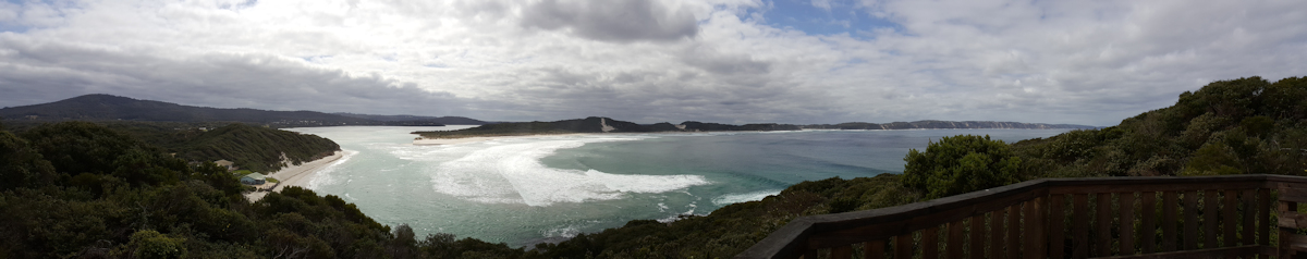
At the top, near two giant wind turbines, we met a Council employee who was involved in the construction of the bitumen track along the dunes who gave us some tips about the descent on the loose gravel and advised us it would be worth turning off at the bottom of the hill to see Lions Lookout. When we reached the lookout we were amazed at the beauty of the inlet, with the waves and rocks near the surf club.
The last 10kms were on a bike track that ran parallel to Ocean Beach Road, making for a very comfortable end to the day's ride.
At Denmark we first found a bakery for our breakfast/lunch and chatted with a couple who were also enjoying the peaceful surroundings. We booked into the Denmark Hotel, with a comfortable unit, up to our normal expectations. Dinner was chicken parmigiana for me and pasta for Matthew. TV in the evening, preparing ourselves mentally for a big finish on Wednesday.
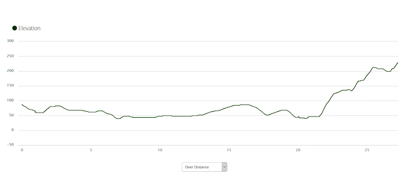
Day 28 - Wednesday 6/9/17 - Denmark to Albany (74.9kms)

The departure from Denmark was initially along an easy bike track next to Denmark River that led to the Wilson Inlet Heritage Trail. This track followed the shore of Wilson Inlet, a beautifully calm scene, even with a pelican near to the shoreline. After 10kms we crossed the South Coast Highway and travelled along single-track for a couple of kilometres before turning away from the highway for an 11kms detour along reasonably good gravel back roads, when we rejoined the highway for another short distance. There were interesting sections of single-track, some good gravel roads and along parts of Lower Denmark Road.
We had a quick stop at Youngs Siding after about 26kms and another break at Elleker after 58kms for a snack and a drink. The trail then followed close by Lower Denmark Road and turned away from the main road to take us through country lanes, before we reached a rail crossing 5kms from Albany.
This is where my problems started! In order to cross the rail line we first needed to manoeuvre our bikes around a tight barrier then lift them up three large steps before actually crossing the rail line. There were four more steps up from the rail line. A nightmare for elderly cyclists riding fully-laden bikes.
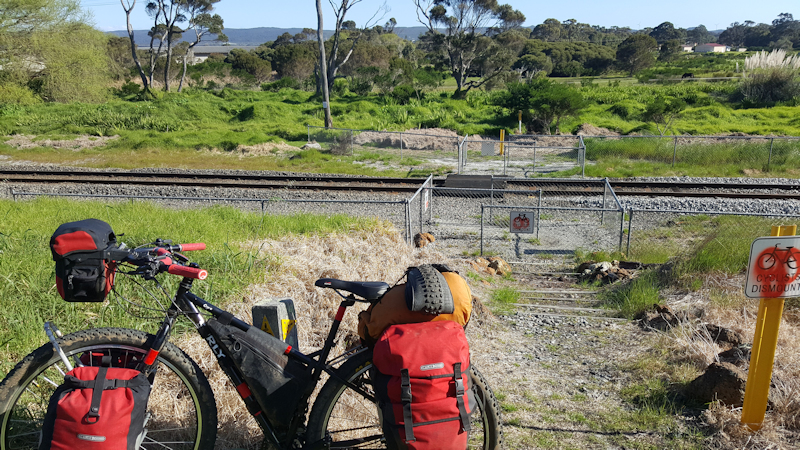
As I was lifting the front of my bike up a step the back wheel was caught at a lower step. I put a bit of extra effort into my lift and, as I did this, I heard a pop and felt a sudden pain in my upper right arm, near my shoulder. I had torn a tendon. Matthew immediately came to my rescue and lifted my bike over to the other side of the rail line. Fortunately, I could still extend my right arm and was able to ride, so we continued on our way.
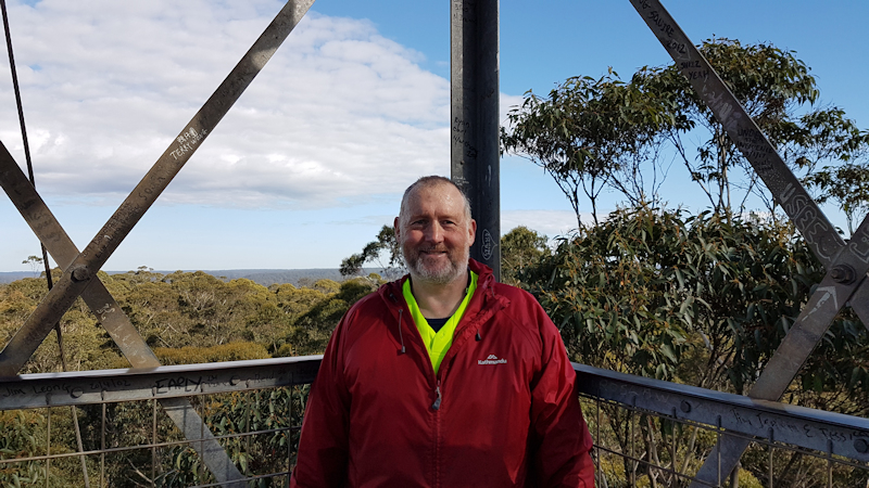
As we approached Albany the trail took us on a left fork up Carlisle Street, an unnecessary, ridiculously steep side road through a monotonous built-up area, away from the more picturesque Princess Royal Drive. This detour eventually led to an equally steep hill down towards the rail terminal, where we eventually found the end point of the Munda Biddi Trail.
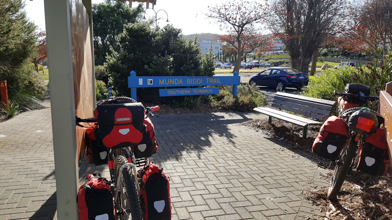
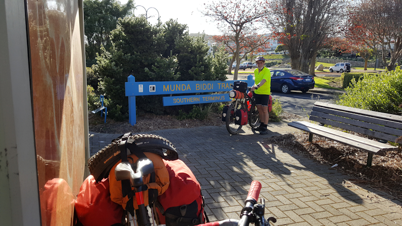

We took a couple of photos and congratulated each other on reaching the end of the trail, even though we had missed a few sections during the previous four weeks of riding.
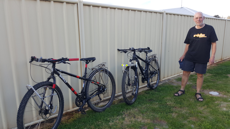
Thanks to my son, Matthew, for being such a wonderful supporter, a brilliant navigator and for helping me over and around huge fallen trees on the trail.
Following the Munda Biddi Trail ride we spent a few days in Albany, getting my shoulder checked out at a local medical centre, riding up to the Anzac Memorial Centre and out to the Whaling Station.
On Sunday 10/9/17 we travelled back to Perth, where Matthew hired a Pajero for a few days to enable us to explore the south-west coastal areas in a bit more comfort than we had become accustomed to.
Once back in Tasmania I was referred to an orthopaedic surgeon who, on 19/10/17, operated on me and performed a reverse total shoulder replacement.
Medical Issues
As it has been for each day of the past seven years, the suprapubic catheter is a nuisance. The catheter site needed to be cleaned with alcohol wipes if washing facilities were not available and the dressing changed daily.
The urine drainage bag needed to be flushed out and cleaned using a bleach tablet dissolved in water each day. This cleaning system worked well and became my preferred method of managing the bag cleaning task, rather than carrying a bottle of bleach in my pannier bag to achieve the same result - which was my previous practice.
The Vesicare tablets that I took each day prevented any bladder spasms from occurring. These tablets were worth buying, even though they were not available to me under the Prescription Benefits Scheme.
The two occasions that I sought professional assistance in changing my catheter, using the spares I took for that purpose, meant that there were no dramas with a blocked catheter, such as I had experienced on previous multi-day bike trips.
Overall, except for the torn shoulder tendon on the final day, I had no health problems.