OVERLAND TRACK FROM SOUTH TO NORTH©
TONY & MATTHEW WATTON
3/6/2010 to 9/6/2010
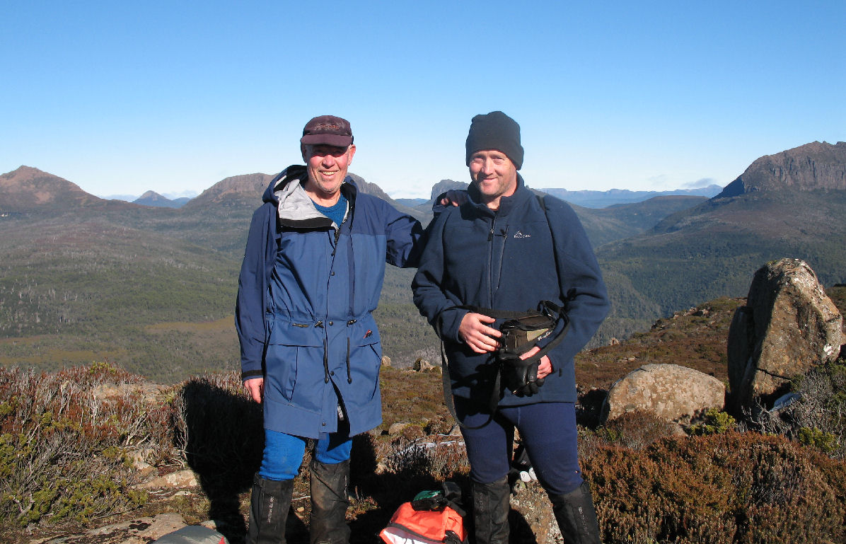
Tony and Matthew Watton on top of Mt Oakleigh
The Plan
Matthew had arranged to have two weeks leave from work so we had the opportunity to do some side trips, as well as actually walking the full length Overland Track (80km) from Cynthia Bay to Ronny Creek Car Park at the Cradle Mountain end. We thought maybe 10 days would be a comfortable length of time to do what we wanted. The possible side trips included Mt Olympus from Echo Point Hut, Hartnett Falls between Windy Ridge Hut and Kia Ora Hut, Mt Pelion East between Kia Ora Hut and Pelion Hut and Mt Oakleigh from Pelion Hut. We thought also that by walking from south to north we would see things from a new perspective - basically a different walk from our earlier trip - Overland Track Winter 2006.
To give us this flexibility we decided to leave a car at each end of the track so we would not need to rely on what we thought may be infrequent buses to get us to and from civilisation during Winter-time.
Day 0 - Wednesday 2/6/10 - Hobart to Cradle Mountain Backpackers
Our car shuffle involved us in driving both cars to Cradle Mountain, where we stayed the night in a Cosy Cabins bunkhouse. Very cosy - in fact a bit too cosy as we had the heater turned up to high all night, whereas we should perhaps have been acclimatising ourselves to the cold nights yet to come.
We had previously bought salad rolls and drinks in Deloraine so these became our main meal for the day.
Day 1 - Thursday 3/6/10 - Cynthia Bay to Echo Point Hut (10km, 3hr 25min)
We left Matthew's car at the Ronny Creek Car Park and were on our way south in my car while it was still dark - about 6.45am.
The drive took us through Tullah and to Queenstown, where we stopped for breakfast - toasted sandwiches and coffee/chocolate milk. At Cynthia Bay we changed into our walking gear and started the walk at 11.45am. Matthew had put two pairs of boots in the car, not sure which he would wear - either his Scarpa hide boots or fabric boots that might have been a bit more comfortable. In the end he opted for the fabric boots.
After we had been walking along the track next to Lake St Clair for about 1hr 30min Matthew managed to stub his left foot against a protruding root and partially punctured the fabric on top of the boot, exposing the inner layer but not completely penetrating the boot. He decided to hide his pack off the track and hurry back to the car to change his boots. This would mean he would probably arrive at Echo Point Hut in darkness, around 5.30pm. This was not a serious problem and certainly not as challenging for him as our second walk to Vera Hut on the Frenchmans Cap Track in winter. See my trip report notes at Frenchmans Cap Walk: August 2007.
Meanwhile, I carried on walking to the hut and arrived at about 3.10pm, much relieved to see that there was a coal stove and a supply of dry sticks and coal. I soon got the stove going to provide a warm welcome when Matthew turned up at around 5.30pm. A very peaceful spot, with no wind, but beginning to cool down. Matthew reached the hut at 5.40pm, very tired after his double walk to get his other boots. Our meal, after a hot chocolate drink, was freeze-dried lamb fettuccine followed by a hot orange drink - not Tang but a substitute as Tang was no longer available.
We found that if we both left the hut at the same time, when we returned there were rat droppings on the food preparation table. We were obviously very careful about where we placed our food.
It was very warm in the hut, with no other walkers arriving during the evening.
Our plan for Friday was to climb Mt Olympus if the weather showed any signs of being favourable.
Day 2 - Friday 4/6/10 - Echo Point Hut to Windy Ridge Hut (15km, 6hr 50min)
A very comfortable night in the hut, except for the rustling of the resident rat. We had a pleasant breakfast of porridge and sultanas with a cup of hot chocolate. We cleaned up the hut, put some dry sticks in the stove, refilled the coal bucket and were on our way at about 9.40am.
As conditions on Mt Olympus were not very encouraging we decided to give the climb a miss on this occasion. Our packs felt really heavy (Matthew was probably carrying the best part of 28kg, while mine was closer to 22kg). We needed frequent rest stops and arrived at Narcissus Hut in rain at 12.30pm. There were several other walkers already there, waiting to get the ferry back to Cynthia Bay, so we made our lunch of a hot chocolate drink and Vita Wheat biscuits with cheese and Vegemite on the steps of the Ranger's Hut. By doing this we avoided trudging our wet clothes in the freshly-cleaned hut.
On our way again by 1.05pm, with our packs getting heavier by the minute due to the continuous rain. At home we had sprayed our packs with silicone to help waterproof them but I'm not sure it was very effective. On the bright side, there was no wind and it wasn't really cold.
Once again, frequent rest stops were necessary to help us on our way. We saw several pademelons and I spotted a pink robin but, by the time I told Matthew, it had gone.
A few walkers passed us, all heading south to finish their walk and we reached the new Windy Ridge (Bert Nichols) Hut just after 4.30pm as we were beginning to lose daylight.
After all the negative stories we had read, ie that the hut is too big to keep warm; it leaks etc, we were pleasantly surprised to see that the already arrived occupants had got the large wood heater going and the eating area was very cosy indeed. The same couldn't be said for the sleeping rooms, however, as these were very cold - probably colder than the air outside. Apparently, people have been sleeping around the wood heater - can't say I blame them.
Plan for Saturday - to visit Hartnett Falls on the way to Kia Ora Hut. Total time on the track may be 5hr 30min to 6hr, compared to about 6hr 50min this day.
Day 3 - Saturday 5/6/10 - Windy Ridge Hut to Kia Ora Hut (10.1km, 5hr)
We spent a very pleasant night, despite the cold sleeping area, and had a relaxed breakfast of porridge and sultanas with a cup of tea. It was about 10.00am when we left for this day's leg of the trip, the last of three groups staying at the hut. The others were heading south to Narcissus and the ferry.
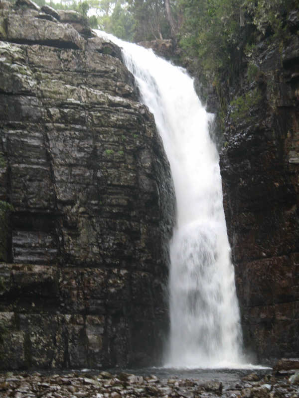
After we had passed over Ducane Gap we left our packs just along the track to Hartnett Falls and continued with light packs and a few emergency supplies. About 20min later we reached the top of the falls and saw the spectacular volume of water gushing over the edge into the gorge. We then followed the side track down to the river and walked back up to the falls to take a few photos. It was well worth the effort. We decided to miss the other falls in the area - Fergusson, D'Alton, Cathedral and Boulder.
When we rejoined the main track I thought we had about 1hr to go to reach Ducane Hut, but we must have been moving more slowly than the guide book recommendations. I expected to see the hut around every corner - it eventually came into view much to my relief. We made our standard lunch snack of Vitawheat biscuits, cheese and Vegemite plus a few cashew nuts but it was too cold (our clothes were wet and it was windy as well) so we hurried on. I was disgusted by the mindless cretins who had vandalized the hut walls with their inane name-carving activities.
As we left Ducane Hut the sign read Kia Ora Hut 45min. We eventually reached the hut in just over 45min to find a family of three had already made the coal fire, so it was very cosy and welcoming.
Pasta with salmon for dinner, followed by hot chocolate drink. Very satisfying and we felt very comfortable.
To Pelion Hut tomorrow - and maybe a side trip, depending on visibility.
Day 4 - Sunday 6/6/10 - Kia Ora Hut to Pelion Hut (8.2km, 4hr 30min)
We enjoyed a pleasant stay at Kia Ora Hut. We were packed and on the track to Pelion Hut by about 9.30am and after about 1hr we passed a lone walker (he had started at Cynthia Bay, walked to Cradle Mountain and was on his way back to where he started from).
Pelion Gap was very cold, with a strong breeze blowing and frost on the track. We had thought about climbing Pelion East but the cloud cover, combined with the lack of motivation, meant we didn't do it. Pathetic!
The descent from Pelion Gap to Pelion Hut was uneventful but took a bit longer than we expected. Probably because of the numerous stretching and rest breaks I needed.
A few groups were staying at this hut, either heading south or out via the Arm River Track after climbing Mt Ossa.
Plan for the next day - to climb Mt Oakleigh. If the weather holds it will be a good day trip. Then another night at Pelion Hut.
Drama - at about 6.30pm fellow campers asked us if we had seen a lone walker who had intended to climb Mt Ossa but had not yet returned to the hut. He left with another walker at about 7.00am and they parted company at Pelion Gap, with the other walker continuing on to Kia Ora Hut. [He was the one mentioned above.]
At the hut it was discovered that he had not taken his GPS, maps of the area or his headtorch.
Matthew made some notes about who he was (from his pack that he left at Pelion Hut) and two other walkers prepared to walk back to Pelion Gap to see if he could be found.
We all held grave fears for his safety as the air temperature was close to 0oC at the hut and it certainly would have been a lot lower at Pelion Gap - about 1,120m high.
To our tremendous relief, at around 7.00pm the walker returned to the hut. Apparently, he had climbed Mt Ossa by 11.00am, where he had injured his right knee (pre-existing injury that was made worse). He struggled down and reached Pelion Gap by about 3.30pm. When it got dark at 5.00pm he continued on, with no more than a crescent moon to help him. When he felt he was straying into the vegetation he moved back on to the track. We all thought it was incredible that he was able to actually get to the hut in darkness without any further injury. However, in our opinions, he should never have allowed himself to be in such a perilous situation in the first place. He seemed to have trouble understanding how serious things could have been. All's well that ends well.
Day 5 - Monday 7/6/10 - Pelion Hut to Mt Oakleigh and Return (9.6km, 5hr)
There was a group staying at the hut that consisted of four mothers and four daughters. The girls were in high spirits and were obviously enjoying the experience. Jane, one of the mothers, came with us on a side trip to Mt Oakleigh. We left at 9.10am with day packs and emergency supplies on a very cold, but sunny, morning.
The walk across the plain took us to the start of the climb, first through forest then, when it became steeper, through fantastic pandani plants. Some of them were over 10m tall - goodness knows how old they might have been.
We reached the plateau in about 2hrs, then took another hour to get over a dome, down into a shallow valley then up to the summit. What a magnificent view! We could see Cradle Mountain, Barn Bluff, Mt Ossa, Mt Pelion East and West and many other peaks in a 360o vista.


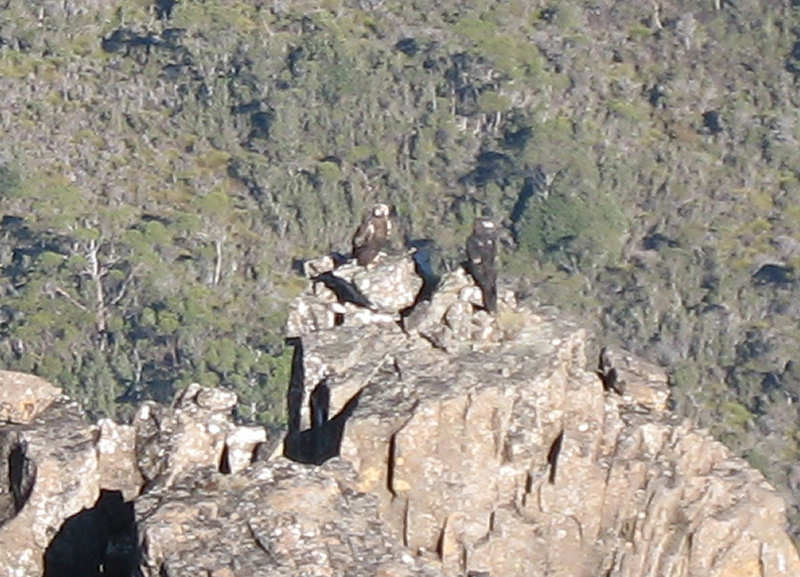
While we were all admiring the view a wedge-tailed eagle flew past us, not more than 20m away, circled round and landed on a large pinnacle about 50m away from the Mt Oakleigh bulk and below our position. It joined another eagle that was already there. A more commanding outlook could not be imagined. Eventually, after we had taken photos, they flew away - a long way below us.
On the way over the plateau Matthew had left his walking poles on the track, just before the valley section but, on the way back, he failed to find them. After a bit of a search we continued along the track and eventually found the poles, further on than he remembered. He said he would have kept looking until he found them.
The walk down was uneventful, except when I found the edge of a deep bog and my right pole and right leg went in to my hip. My foot had not touched the bottom of the hole. A most uncomfortable experience and not one that I want to repeat any time soon.
This was a great trip in beautiful weather. The eagles made it very special.
Day 6 - Tuesday 8/6/10 - Pelion Hut to Windermere Hut (14.2km, 7hr)
We decided to have an earlier start for this leg of the journey as we were covering a greater distance. We were packed and ready to go by 8.20am. The track took us through forest, a distance of 1.5km down to Frog Flats. From there we faced a steady 2.5km climb in forest, spiralling up around Mt Pelion West, passing Mt Oakleigh on the right, which we didn't see. Pine Forest Moor came next, on a good track that was either boards or rock. It was very cold on the moorland.
We passed the Forth River Lookout but, because of poor visibility, we didn't go over to check it out this time. We did not stop for our customary biscuits and cheese because we wanted to press on and get to the hut as soon as possible.
The track then dropped to pass Lake Curran before a moderate hill brought us to Windermere Hut. Matthew had gone on ahead of me and so arrived at the hut about 10min before I did. So, by the time I got there he had the gas heater lit, to raise the hut temperature from the 4oC when he started it.
One by one, two other families totalling seven in all arrived at the hut, all heading in the same direction as we were. There was plenty of room for all - with no noisy kids this time. A pleasant evening was spent drinking cups of tea and hot chocolate with some nuts and biscuits for nibbles. We played Hangman with cities and towns. Matthew bamboozled me with the town 1770 - just too smart.
Day 7 - Wednesday 9/6/10 - Windermere Hut to Ronny Creek Car Park (17.4km, 7hr 20min)
Matthew had listened to weather forecasts during the previous evening and learned that snow was predicted to fall at levels above 400m and there were Bushwalker Alerts, as well as others for Wednesday.
We had previously talked about a short walk to Waterfall Valley Hut (about 2hrs) then a 5hrs+ walk on Thursday to finish.
However, with the prospect of bad weather we thought things may be even worse on Thursday so we decided to bite the bullet and walk out on Wednesday.
I was up at 4.45am, made a cup of tea and tried, unsuccessfully, to get the gas heater started so gave up. Not worth getting back into the sleeping bag so I dozed on and off on a bench, wrapped up in my down jacket.
At 6.00am I woke Matthew, had another cup of tea and made one for Matthew. No hot breakfast. We packed quickly and quietly, trying not to disturb the other hut occupants, who were starting out later than we were.
At 7.40am we left the hut in cold but fine conditions, with an extra thermal top on and balaclava and gloves easily available.
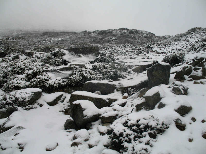
By the time we had climbed the hill to the plateau near the Lake Will turnoff at 1,100m it was snowing, making it necessary to take extra care on slippery boards. We trudged on, meeting three walkers heading in the opposite direction. The last two told us the heater in Waterfall Valley Hut had turned off not long before so we were really looking forward to getting there for a short break.
Just before the hut we saw waterfalls cascading over the edges of the valley rocks - quite spectacular.
We were at the hut by about 10.00am and spent 30min warming our gloves and hands while we had a snack and a drink.
Before we left I put on my balaclava and Matthew put on his polar fleece under his rain jacket.
As soon as we got going again we faced a significant climb up onto the plateau at over 1,200m. Here weather conditions were dramatically worse than before. A strong westerly wind blew thick clouds of snow horizontally in blizzard conditions. There was no view so we relied on seeing landmarks, such as the Barn Bluff turnoff and Scott Kilvert Hut turnoff and were very relieved to see Kitchen Hut just to the left of the track near the Cradle Mountain turnoff.

Even though we were glad to get into the hut we stayed for only a few minutes. It was good to have our packs off our backs as we had not taken them off since we left Waterfall Valley Hut. When we started off again on the final leg my hands had never been so cold. Even with the effort of walking it took quite a while for me to go through the excruciatingly painful process of re-warming my hands. When we reached Marions Lookout Matthew suggested that we go down the steep, rough track directly to Dove Lake in order to get out of the strong wind as soon as we could. I was happy to agree.
The snow-shrouded shrubs and trees on the descent looked absolutely beautiful. However, taking photos without a waterproof camera would not have been a good idea so all we have are our memories.
At the terminus of the shuttle bus we were tempted to get a lift back to Ronny Creek Car Park but decided instead to walk back to Matthew's car to finish the walk "properly".
What a relief - at about 3.00pm - to find the car intact, even though covered in 100mm of snow. We were then looking at a 7hrs+ slow trip back home via Lake St Clair to recover my car that we had left at the start of the walk.
Much of the drive back was at no more than 40kms/hr owing to the treacherous road conditions - snow falling and a slippery road.
So ended a very enjoyable but challenging walk - 80kms plus Mt Oakleigh and Hartnett Falls side trips in seven days.
Great son and a great companion. Thanks Matthew.
Medical Considerations
Neither Matthew nor I suffered any injuries. That is, if sore shoulders aren't counted. From the start I had strips of adhesive tape where the pack straps were and on my heels and so did not have any cuts or blisters.
In common with our last two trips - Port Davey Track in December 2009 and Precipitous Bluff Walk in January 2010 - I took care of my suprapubic catheter by daily cleaning with alcohol swabs and clean dressings. I have now become used to the routine and feel that I can cope well with this inconvenience. It is not stopping me from doing what I want to do.